A model project, and why Bandera County
This is a model project, not a built one: a 150 to 250 site RV resort placed in unincorporated Bandera County to show how the county's rules, and the state rules above them, shape a Hill Country site plan. No developer, parcel or approval is implied. The program is a destination resort with a clubhouse, pool, pickleball, a dog park and an optional cabin or park model section on a 20 to 60 acre parcel.
Bandera is the primary jurisdiction because its full rule set can be read and quoted section by section. Of the six Hill Country counties screened (Comal, Kendall, Kerr, Bandera, Burnet and Llano), none publishes a dedicated RV park infrastructure order. Bandera's Subdivision and Land Development Regulations (adopted April 21, 2005; revised through August 25, 2022; file dated 01/11/2024) carry the operative text: a sealed engineering requirement, a 60 ft right of way, a 22 ft local road, a 1 ft freeboard rule, a 24 hour aquifer test and a $250 plus $10 per space review fee [2]. They "govern the unincorporated areas of Bandera County and hold no force inside corporate city limits except where there is an interlocal agreement" (1.3.4) [2]. Kerr County holds the only documented local comparable for an RV resort, so it supplies part of the comparison set. For the statewide regime see RV park site plans in Texas and the Texas site plan hub; for the county process across the state see RV park approval in Texas counties. The asset hub is RV resort site plans.
| Item | Model project |
|---|---|
| Asset | Destination RV resort |
| Program | 150 to 250 RV sites; clubhouse, pool, pickleball, dog park; optional cabin or park model section |
| Parcel | 20 to 60 acres, unincorporated |
| Jurisdiction | Bandera County Commissioners Court and County Engineer; BCRAGD, the groundwater district, comments on groundwater [2] |
| Zoning | None: the county is unzoned [1] |
| Permit type | Plat track under LGC Ch. 232 if the county treats the resort as a subdivision; infrastructure plan (Appendix A) for any park model or manufactured home section; state permits for water, wastewater, access and floodplain [2] |
| Appendix A scope | Land rented or leased "for a term of less than 60 months without a purchase option, for the installation of manufactured homes" (App. A 1.1) [2] |
| Groundwater status | The State "has declared Bandera County to be a Priority Groundwater Management Area" (1.1.1(l)); Bandera was the first county to use Water Code Sec. 35.019 [2] |
| Published review fee | $250 plus $10 per rental space (App. A Sec. 7) [2] |
The county layer: Chapter 232 and no zoning
Texas counties have no general zoning. As the Texas Association of Counties handbook sets out LGC 232.101(b), a commissioners court may not regulate the use of any building or property for business, industrial, residential or other purposes, or the number of residential units that can be built per acre [1]. Counties instead regulate subdivision plats and infrastructure under Chapter 232 [3]. Site count on unincorporated land is therefore set by infrastructure, not by a density cap: road geometry, drainage, the OSSF field or treatment plant footprint, well yield and the floodplain [1].
Whether a county may treat a leased-space RV resort as a "subdivision" is contested. LGC 232.007 gives counties infrastructure plan authority over manufactured home rental communities, not RV parks [3]. Bastrop County's lodging and RV park rules state that such developments "are subdivisions under Chapter 232" and cite Attorney General Opinion GA-1007, with a 30-day review under LGC 232.0025 [4], and the Texas Association of Counties also points to GA-1007 [1]. Bandera's Appendix A is written for manufactured homes, and the words "recreational vehicle" and "RV park" do not appear in it or in the main regulations [2]. Settle the county's position in writing at the pre-application meeting, before the layout is fixed.
Two state rules also bear on Bandera's 2005-era multi-stage process. LGC 232.00285 bars a county from requiring a development plan, a term that includes a preliminary plat and a site plan, unless other law explicitly authorizes it, and LGC 232.001(h) (2023) bars requiring an analysis, study or document that state law does not explicitly require [1]. A developer can therefore question whether the preliminary plan and preliminary plat stages are mandatory for a leased-space resort.
Inside a city the regime changes. Under the City of Burnet's Ordinance 2022-34, adopted and effective August 23, 2022, an RV park is "only allowed in Heavy commercial, District C-3 with a conditional use permit" [5], and the City of Llano regulates RV and travel trailer parks in Chapter 62, Division 2 [6]. A city acts on a plat under LGC 212.009(a): it approves, approves with conditions or disapproves within 30 days after filing, and a plat it does not disapprove is approved; since HB 3699 (2023) the applicant may extend that period in writing for one or more periods of up to 30 days [7, 8]. For land in the City of Bandera's ETJ, Bandera 1.3.5 notes an interlocal agreement, and "Applicants will be subject to County regulation, and should consult with the County Engineer" [2]. For a city-side process in the same region, see San Antonio site plans.

Approval path
Every approval in order, as the Bandera regulations, state law and TCEQ guidance set it. Fees and timelines the documents do not publish are marked "Not stated". The plat stages run in sequence: "Submittal, review and consideration of the Preliminary Plan, Preliminary Plat and Final Plat shall be consecutive, not concurrent, and shall be considered by Commissioners Court during separate meetings" (3.1.4) [2].
| # | Approval | Body | Code section | Stage | Fee | Timeline | Seal |
|---|---|---|---|---|---|---|---|
| 1 | Sketch plan (optional) | Precinct Commissioner and County Engineer; Commissioners Court receives it, not approved | 3.2, App. K | Pre-application | None stated | 7 copies at least 10 days before court [2] | None: the rules set no content requirements |
| 2 | Application | County Engineer | 3.3 | Intake | Not published in the regulations | With the preliminary plan | No |
| 3 | Preliminary plan | Commissioners Court, conditional approval | 2.2.20, 3.4 | Feasibility | Not published | 7 prints at least 30 days before court; expires in 12 months [2] | Prepared by a registered surveyor or engineer |
| 4 | Preliminary plat | Commissioners Court; BCRAGD comments | 3.5, 4.2, 6.1.3 | Design | Not published | 7 prints at least 30 days before court; expires in 12 months [2] | Engineer or surveyor certifies; PE seal on road and drainage plans |
| 5 | Groundwater availability certification | County, reviewed by BCRAGD | 4.2, 4.10.3; LGC 232.0032; 30 TAC 230 | With the preliminary plat | Not stated | 24 hour minimum aquifer test [2] | PE or P.G. "signature, seal and date" |
| 6 | Final plat | Commissioners Court; County Clerk records | 3.6, 9.4.3 | Record | $100 plus $3 per lot over 33; $5 records; $5 archives; $1 security [2] | 8 prints and mylar at least 30 days before court | Engineer or surveyor certifies |
| 7 | Construction bond | Commissioners Court | 10.1 to 10.3 | Pre-construction | Based on the engineer's cost estimate | Start within 90 days and finish within 12 months of final plat approval [2] | Engineer's estimate |
| 8 | Infrastructure development plan (IDP) and final survey, park model or manufactured home section | Commissioners Court | App. A Sec. 4 to 6 | Infrastructure | $250 plus $10 per rental space [2] | Confirm with the County Engineer | Original RPLS and PE seals |
| 9 | Statutory plat clock | Commissioners Court or designee | LGC 232.0025 | All plat stages | Per LGC 232.0021 and 232.901 | 10 business days to flag an incomplete filing; 30 days to decide [1] | Not stated |
| 10 | Floodplain development permit | County floodplain administrator | Flood Damage Prevention Court Order (6.1); Water Code 16.315 | Pre-construction | Not stated | Not stated | Not stated |
| 11 | Wastewater: OSSF permit, or a TCEQ domestic wastewater permit above 5,000 gpd [9] | County OSSF program or TCEQ | Bandera Art. 5; HSC Ch. 366; 30 TAC 285 | Design | Not stated | A discharge permit can go to a SOAH contested case | PE or registered sanitarian (5.1.3) [2] |
| 12 | Public water system approval | TCEQ | 30 TAC 290.38(47), quoted in Bandera 2.2.22; 30 TAC Ch. 290 | Design | Not stated | Not stated | Not stated for Bandera |
| 13 | Construction stormwater, TXR150000 | TCEQ | Construction General Permit, effective March 5, 2023, expiring March 5, 2028 [10] | Pre-construction | Not stated | Before starting, when 1 acre or more is disturbed [9] | SWPPP |
| 14 | Access | TxDOT on a state highway; Commissioners Court on a county road | 6.6 | Before final plat | Not stated | Before final plat approval [2] | Not stated |
| 15 | Wells | BCRAGD | 4.7.3(j), 9.3(d) | Construction | Not stated | Not stated | Not stated |
| 16 | Campground flood safety: evacuation plan, ladders in floodplain cabins | Campground operator, with a copy to local authorities | SB 1 (89th, 2nd C.S.); HSC Ch. 762 | Pre-operation | Not stated | In force since September 5, 2025 [11] | Not stated |
| 17 | Certificate of compliance, IDP section | Commissioners Court | App. A Sec. 6 | Close-out | None stated | Final inspection by the 2nd business day after notice; certificate by the 5th business day [2] | Not stated |
The only stage the county frees from content and preparer requirements is the sketch plan. The preliminary plan is prepared by a registered surveyor or engineer, road and drainage plans must be "signed and sealed by a Professional Engineer" before preliminary plat approval, and IDP originals "should have original seals and signatures" of both the RPLS and the PE [2]. Utility connection is the practical occupancy gate for an IDP section: "A utility may not provide utility services ... to an MHRC until a Final Survey and an Infrastructure Development Plan have been approved" (App. A 3.1) [2]. On a discharge permit that goes to a contested case, the San Antonio Report reported that the State Office of Administrative Hearings alone "has up to six months to set a hearing" [12].
Design standards that bind the layout
The regulations contain no site size, site separation, setback or density standard specific to RV spaces [2]. The layout is shaped instead by the road, drainage, utility and groundwater standards below, all from the Bandera regulations unless noted.
| Standard | Value | Section |
|---|---|---|
| Right of way, collector and local roads | 60 ft [2] | 6.1.1; App. B 13.0 |
| Right of way, arterial | 100 ft | 6.1.1 |
| Alleys | 20 ft wide, 8 in base | 6.1.1; 6.10 |
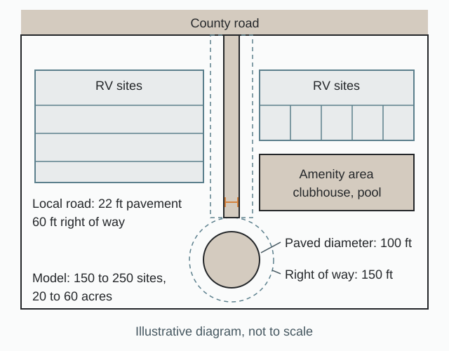
| Dead-end turnaround | 150 ft right of way diameter; 100 ft paved diameter [2] | 6.1.1; App. B 12.0 |
| Pavement width | Local 22 ft; collector 24 ft; arterial 28 ft; 4 ft shoulders [2] | App. B Figs. 1 to 3 |
| Uncurbed road section | 8 in compacted flexible base, at least 30 ft wide [2] | 6.9 |
| Curbed section | 8 in base, 30 ft face to face; next increment 40 ft | 6.10; App. B Fig. 4 |
| Flexible base | 8 in compacted, two courses, 95% density [2]; material to TxDOT Standard Specifications Item 247 | 6.8; 6.9; App. B 9.0 |
| Surface | Two-course surface treatment or 1.5 in HMAC with prime | 6.11; App. B 10.0 |
| Maximum grade | Local and collector 12%; arterial 6% [2] | App. B Table 4 |
| Stopping sight distance | Local 250 ft; collector and arterial 300 ft [2] | App. B Table 1 |
| Minimum centerline radius | Local 100 ft; collector 400 ft; arterial 700 ft [2] | App. B Table 3 |
| Intersection angle | 90 degrees; under 80 degrees needs a corner cut of at least 25 ft | 6.1.2 |
| Road jogs | Avoid centerline offsets under 125 ft | App. B 14.0 |
| Contours | 2 ft for grades up to 5%; 5 ft over 5% (plat: 5 ft) | App. B 2.0(e); 3.5.3(d) |
| Drainage design storm | Structures and channels 25-year; roadside ditches 2-year; Rational Method under 640 acres [2] | App. B Storm Drainage |
| Channel freeboard | 0.5 ft (0 to 5 ft flow); 10% (5 to 10 ft); 1.0 ft (10 ft and over) [2] | App. B Table 7 |
| Earth channel side slope | Not steeper than 3:1 | App. B 4.0(c) |
| Driveway | 10 ft minimum width; 12% maximum grade; 18 in minimum culvert | App. B Fig. 9; 7.0 |
| Utility burial | Top of pipe at least 24 in deep | 7.1.1 |
| Utility easements | At least 20 ft dedications; 10 ft perpetual easements along rear, front and side lines [2] | 3.6.13; 7.2.2 |
| Lot size if land is subdivided for sale | 10 acres and 200 ft frontage (well and OSSF); 5 acres and 150 ft (public water and OSSF); 0.5 acres and 100 ft (public water and sewer); cul-de-sac 50 ft chord [2] | 8.1.1 to 8.1.4 |
| Finished floor, IDP section | At least 1 ft above base flood elevation [2] | App. A 4.1.14 |
| Peak flow, IDP section | No increase in post-development 100-year peak flow | App. A 4.1.14 |
| IDP space frontage with OSSF | 50 ft | App. A 4.1.7 |
| IDP sheets | 24 by 36 in; scale not exceeding 1 in = 200 ft; lettering at least 0.09 in [2] | App. A 4.1.1 |
| Groundwater test | At least 24-hour uniform rate; one test and one observation well per 100 acres; 10-year and 30-year availability [2] | 4.7.3(a); 4.7.3(f-1); 4.9.1 |
| Monitoring well | 4 in casing, dedicated to BCRAGD, 10 ft radius, public road access | 4.7.3(j) |
| Fire water storage (state option) | Under 50 units 2,500 gal; 50 or more units 2,500 gal with centralized water or 5,000 gal [1] | LGC 232.109 |
The provisions that most constrain the layout, quoted from the regulations:
"Collector and Local roads shall have a minimum right-of-way width of sixty (60) feet... A permanent dead-end street shall have a turn-around having an outside right-of-way diameter of 150 feet." (6.1.1) [2]
"Where a street or road section is constructed without curbs, the flexible base shall have a minimum thickness of 8" after compaction ... and a minimum of 30 feet wide." (6.9) [2]
"Two sets of Road and Drainage construction plans signed and sealed by a Professional Engineer shall be submitted to the County Engineer before the Preliminary Plat approval is given by Commissioners' Court." (6.1.3) [2]
"'Flag Lots' or other contrivances which unduly inhibit proper road maintenance or result in lengthy private drives that are likely to restrict the practicable ingress and egress of emergency vehicles in all types of weather are prohibited." (App. A 4.1.13) [2]
"If utilizing individual on-site sewage facilities, each Lot must meet the requirements of the Bandera County Rules for On-Site Sewage Facilities ... Each Lot shall have a minimum of 50 feet of road frontage." (App. A 4.1.7) [2]
"Finished floor elevations must be at least one foot above base flood elevation." (App. A 4.1.14) [2]
"Unconventional layouts, or layouts that will cause unsatisfactory drainage conditions, or that will complicate maintenance of streets, or any land dedicated for public use, will not be accepted." (3.6.9) [2]
"The sub-divider shall ascertain and certify that an acceptable OSSF system can be installed on each tract or lot in subdivision unless public sanitary sewer collection facilities are made available to the site." (5.2.2) [2]
Two state layers now sit over the county text. The Senate Research Center analysis of C.S.S.B. 1 (89th, 2nd C.S.) describes a new Chapter 762 that:
"Requires a campground to comply with the National Fire Protection Association 1194, Standard for Recreational Vehicle Parks and Campgrounds, 2021 Edition, other than Sections 1.1.1 and 5.1.1.1" [13]
The House bill analysis adds that the bill limits local regulation of sanitation, electrical, LPG and fire protection [14], and the enrolled bill codifies the requirement as Health and Safety Code Chapter 762, "Campground Safety" [15]. The bill was signed and took effect September 5, 2025, per its LegiScan bill history [16]. Note the edition: NFPA lists the 2026 edition of NFPA 1194 as current, issued 10/16/2024 [17], while the Texas text names the 2021 Edition. SB 1 also requires campground operators to "develop an emergency evacuation plan," with a copy to local authorities, and to install roof-access ladders in floodplain cabins; the House floor report counts an RV park as a campground [11]. In flood zones, federal NFIP rules require an RV in a special flood hazard area to meet manufactured home elevation and anchoring unless it is on site fewer than 180 consecutive days or is fully licensed and ready for highway use (44 CFR 60.3(c)(14)) [18].
Because Bandera sets no RV site geometry, adopted Texas county RV orders elsewhere are the nearest benchmarks. None of them binds a Bandera site. For how site counts per acre compare across states, see RV sites per acre and RV park regulations by state.
| Benchmark from another county (not binding in Bandera) | Value | Source |
|---|---|---|
| Parker County benchmark: pad | Hardened area at least 12 ft by 40 ft | Parker County order [19] |
| Parker County benchmark: setbacks | 25 ft from public ROW, 15 ft from property line, 15 ft from internal road | Parker County order [19] |
| Parker County benchmark: separation | 12 ft between RVs with slide-outs extended | Parker County order [19] |
| Parker County benchmark: minimum tract | 5.0 acres | Parker County order [19] |
| Wilson County benchmark: separation | 10 ft between units | Wilson County requirements [20] |
| Jefferson County benchmark: internal roads | One-way 20 ft, two-way 24 ft, cul-de-sac 50 ft radius, 65,000 lb design load | Jefferson County Appendix 7 [21] |
| Fannin County benchmark: density | Max 10 RVs/acre | Fannin County order [22] |
Determination: as proposed and as resized
At this scale the water system, the wastewater system and the floodplain decide the program, and the internal road standard is the fourth variable. The table sets the brief against what the rules do to it. The sources state no final site count after these constraints, so none is given here.
| Element | As proposed | As resized by code and site | Rule |
|---|---|---|---|
| Site count | 150 to 250 sites | No county density cap; the count is the residual after roads, drainage, the wastewater footprint, well yield and the floodplain [1] | LGC 232.101(b) |
| Water | Wells serving the resort | A public water system at 15 connections or 25 individuals for 60 days a year: TCEQ plans, well capacity, storage [2] | 30 TAC 290.38(47) |
| Wastewater | On-site sewage facility (OSSF) | Burnet County's design flow of 100 gallons per RV space gives 15,000 to 25,000 gpd for 150 to 250 sites [23]; above 5,000 gallons a day RG-499 requires a domestic wastewater permit [24] | 30 TAC 285; TCEQ permit |
| Groundwater | Well field sized to demand | PE or P.G. certification with drawdown at 10 and 30 years and "a recommended minimum spacing limit between individual wells" (4.9.1, 4.9.4(c-2)) [2] | Art. 4 |
| Internal lanes | Private internal resort lanes | Whether the county applies its 22 ft, 60 ft right of way public road standard to private internal lanes is the single largest layout variable; any IDP section needs all-weather roadways suitable for two-way traffic [2] | 6.1.1; App. A 4.1.13 |
| Riverside sites | Sites along the water | Moved out of mapped and estimated flood areas; much Kerr floodplain is "Zone A," lacking detailed study, so BLE estimates are needed [25] | Water Code 16.315 county flood orders |
| Cabin or park model section | Optional section in the brief | A separate IDP section: finished floors at least 1 ft above base flood elevation, no increase in 100-year peak flow, RPLS and PE seals, $250 plus $10 per space [2]; roof-access ladders in floodplain cabins under SB 1 [11] | App. A 4.1.14; Sec. 7 |
| Phasing | Full 150 to 250 site program | Phased final plats, with each phase's final plat date stated on the preliminary plan [2] | 3.4.3; 3.6.18 |
The wastewater line deserves care. Burnet County adopted its design flow because RVs "are being used as full time residences therefore a flow rate of 100 gallons per day per space will be required" [23]. TCEQ's RG-499 puts the 5,000 gpd threshold at "approximately 100 hookups" and says such a facility "must be operated at least five days a week by a licensed wastewater operator" [24], and TCEQ's RV park page says an OSSF treating more than 5,000 gallons a day may need a domestic wastewater permit [9]. The OSSF rules, as Burnet County posts them, define an RV park by a combined wastewater flow of less than 5,000 gallons per day [26], and Comal County requires engineered planning for any on-site sewage system serving recreational vehicle parks [27]. Which design flow applies decides whether a first phase can stay on an OSSF permit, and the engineer of record sets it. A discharge permit is a real hearing risk in this region: the Grape Creek case below went to a contested case hearing.
A riverside program is also exposed. In Kerr County a floodplain determination or permit "is required for any work in the floodplain" [25]. The federal RV exemption from elevation and anchoring covers only a stay of fewer than 180 consecutive days or a highway-ready unit [18], and SB 1 adds evacuation planning and cabin ladders in the floodplain [11].
Site data and yield
The site data table below carries the items that govern this model. Values are from the sources cited; the two secondary benchmarks are national, not Texas-specific.
| Site data item | Model value | Source |
|---|---|---|
| Gross parcel | 20 to 60 acres | Model brief |
| RV sites | 150 to 250 | Model brief |
| Zoning district | None (unzoned county) | LGC 232.101(b) [1] |
| Density cap | None at county level | [1] |
| Practical density benchmark | 8 to 12 sites per acre (secondary, not Texas-specific) | [28] |
| Site dimensions | 30 x 50 ft back-in to 45 x 70 ft pull-through (secondary) | [29] |
| Local road | 60 ft right of way; 22 ft pavement; 4 ft shoulders | 6.1.1; App. B [2] |
| Turnaround | 150 ft right of way; 100 ft paved | 6.1.1 [2] |
| Flood | FIRM panel and date on the preliminary plat; IDP finished floors 1 ft above BFE | 3.5.3; App. A [2] |
| Water | Public water system at 15 connections or 25 individuals for 60 days | 2.2.22 [2] |
| Wastewater design flow | 100 gallons per RV space per day; 15,000 to 25,000 gpd at program scale | Burnet County order [23] |
| Groundwater test | 24 hour minimum; one test well and one observation well per 100 acres | 4.7.3 [2] |
| Fire water storage | 2,500 gal with centralized water, or 5,000 gal, at 50 or more units | LGC 232.109 [1] |
| IDP review fee | $250 plus $10 per rental space | App. A Sec. 7 [2] |
Yield on this site is not a density calculation. The largest single layout variable is whether the county applies its public road standard to private internal lanes [2]; resolve it in writing at the sketch stage, then draw the site count that the road decision, the flood exclusion, the wastewater footprint and the well yield leave. Drawing both road scenarios on the plan puts that decision in front of the court in measurable form. For the arithmetic of sites per acre in a state that does set a cap, see the Polk County, Florida case.
Comparable approvals and denials, 2021 to 2026
No Commissioners Court approval, variance or denial of a private RV park for 2021 to 2026 was found in the six counties, and Bandera's court briefings for 2021 to 2025 show no RV infrastructure plan item. The comparables below are the regional cases that show what a resort of this size meets: an operating Kerr resort, the county's own RV hookups, the TCEQ wastewater proceedings an RV-scale discharge can trigger, and the local rules that changed.
| Project or action | Jurisdiction | Program | Outcome | Conditions and themes |
|---|---|---|---|---|
| Old River Road RV Resort | Kerr County | Operating RV resort | The floodplain administrator issued a "no rise" certificate, per an advocacy site [30] | Flood exposure at the "confluence of the Guadalupe River, Turtle Creek and Nowlin's Hollow"; a single exit "only wide enough for one RV at a time"; septic (advocacy source) [30] |
| Mansfield Park RV area (county-owned, context only) | Bandera County | 31 30-amp and 7 50-amp hookups | Rental contract approved 8/10/2023 [31] | A county facility listed for context, not a private approval |
| The Village at Grape Creek, LLC, TPDES WQ0016363001 | Gillespie County (Fredericksburg, U.S. Highway 290) | Tiny home village discharging "up to 20,000 gallons per day... into the Pedernales River" (RV-scale flow; not an RV park) | Referred to a SOAH contested case, Docket 582-25-15494; preliminary hearing May 19, 2025 [32] | Hearing requesters included Hill Country UWCD, Stonewall WCID, Pedernales River Alliance, GEAA and TRPA [32] |
| Gram Vikas Partners, WQ0015990001 | Comal County | 0.20 MGD discharge to Mesquite Creek (not RV) | Hearing requests by GEAA and TRPA [33] | Water quality, Edwards Aquifer |
| Chesmar Homes and GBRA, WQ0016516001 | Comal County | 460,000 gpd land application on 117 acres (not RV) [34] | SOAH preliminary hearing set for Oct 12, 2026 [35] | Comal River, Edwards Aquifer, wells [34] |
| Kendall development agreement (03/04/2025 agenda) | Kendall County | Use not identified | On agenda | Rainwater harvesting, fire code impounded water, Dark Sky compliance, OSSF [36] |
| Ordinance 2022-34 | City of Burnet | RV parks moved from by right in C-3 to a CUP | Adopted and effective August 23, 2022 [5] | Use "may not be compatible with surrounding uses of properties" [5] |
| Plat deadline suspension | Kerr County | Statutory plat deadlines | Suspended July 22, 2026 under LGC 418.016(e) [37] | Filings in a disaster period lose the 30 day clock |
Old River Road may predate the window: an advocacy post refers to a plan proposed in 2009, and a directory says the business was founded in 2011 [38, 39]. It is a contextual comparable, not a model approval, and its opposition themes, flooding and a single exit, are the questions a Hill Country hearing now asks. Mansfield Park is Bandera's own county-owned RV area, listed for context only [31].
The politics moved after the July 2025 flood. The Houston Chronicle reported that of the 136 people confirmed killed in the July 4, 2025 flood, "at least 44" died in RV parks or campgrounds [40]. SB 1 (89th, 2nd C.S.) followed, signed September 5, 2025 [16]. ProPublica and The Texas Tribune reported on May 9, 2026 that "Kerr County, however, has not changed its rules in any significant way," while "some local governments adopted their own, including limiting RV use in flood-prone areas" [41]. The county text has not changed; the questions asked at hearings have, and a riverside layout should expect evacuation, single-exit and warning questions. The Texas floodplain and zoning post and waterfront campgrounds in Texas cover the same exposure from the investment side.
Cost and phasing benchmarks
No primary Texas cost source was obtained, so per-site figures here are national, secondary and directional. County fees are primary.
| Benchmark | Figure | Source |
|---|---|---|
| Total development per site | $15,000 to $35,000 | rvpark.world (secondary, not Texas-specific) [28] |
| Cost per site | $15,000 to $50,000+ | RoverPass (secondary) [42] |
| Resort-quality property | "$5 million or more for 100-site resort-quality properties" | RoverPass (secondary) [42] |
| Density rule of thumb | 8 to 12 sites per acre | rvpark.world (secondary) [28] |
| Site dimensions | 30 x 50 ft back-in to 45 x 70 ft pull-through | PropertyBuild (secondary) [29] |
| Opening phase | "25-30 sites first" | rvpark.world (secondary) [28] |
| Bandera IDP review fee | $250 plus $10 per rental space | App. A Sec. 7 [2] |
| Bandera plat recording | $100 plus $3 per lot over 33, plus $5 records, $5 archives and $1 security | Art. 9.4.3; App. L [2] |
Phasing follows the plat. "A Preliminary Plan may show proposed phased development ... with respective phases to be approved in separate Final Plats," it must "state the date by which the Final Plat application for each phase shall be submitted" (3.4.3), and "A subdivision may be platted and developed in phases" (3.6.18) [2]. Because construction must start within 90 days and finish within 12 months of final plat approval [2], each phase is platted when it is ready to build, on the same water and wastewater backbone, with the first phase sized under the wastewater permit capacity. Engineering review fees are not printed in the regulations [2].
Submittal anatomy: what the preliminary plan carries
The Bandera checklists split cleanly between layout content and engineering content. The preliminary site plan carries the first; the surveyor and engineer of record add the second.
| Stage | Bandera requires | Preliminary plan carries | Engineer or surveyor of record adds |
|---|---|---|---|
| Sketch plan (3.2) | "entire area of every tract"; no mandatory content [2] | Full layout, site counts, amenities, yield table | Nothing |
| Preliminary plan (3.4.2) | Tract and right of way boundaries; proposed lots and easements; road surface and right of way dimensions; street and drainage locations; acreage; scale and north arrow; index map; phase lines and dates [2] | Layout, phasing, site data tables | Boundary survey; registered preparer |
| Preliminary plat (3.5.3, App. I) | 18 by 24 in sheets; adjoiners within 50 ft; bearings and distances; schematic water and sewer; 5 ft contours; 100-year floodplain with FIRM panel and date; pavement and drainage structures; lot and block IDs; 911 letter; power letter; water and wastewater availability letter; OSSF planning report; groundwater certification [2] | Program areas, schematic utility corridors, flood avoidance concept | Survey, topography, FIRM data, sealed road and drainage plans, groundwater test |
| IDP for a park model section (App. A 4.1) | 24 by 36 in sheets at 1 in = 200 ft or larger; vicinity map; taxing districts; space numbers and areas table; utility approval letters; 911 letter; drainage plan with floodway; finished floors; engineer certification; CCRs; tax certificates [2] | Space layout, space-area table, road hierarchy, amenity siting | Bearings to 0.01 ft, benchmarks, sealed drainage design and finished floor certification |
| Final plat (3.6, App. J) | Scale under 200 ft per inch; tie to an original survey corner; key map on USGS at 1 in = 2,000 ft; curve data; dedications; acreage by survey; flood lot elevations; mylar, PDF, fiscal surety, approved construction plans [2] | Nothing new | All survey content |
The seal boundary is written into the definitions [2]:
"A map showing a potential subdivision of land not required to be drawn with precision" (2.2.27, sketch plan)
"All plan and profiles shall bear the seal of a Registered Professional Engineer" (App. B 2.0(f), road plans)
"All original materials should have original seals and signatures of the Texas Registered Professional Land Surveyor and Texas Registered Professional Engineer who prepared them" (App. A 4.1, IDP)
The preliminary plan is "prepared by registered surveyor or engineer" (2.2.20), so in Bandera the studio layout goes in at the sketch stage and becomes the drawing the surveyor and engineer of record build the preliminary plan and plat on.
Conditions and handoff
The conditions that recur in this region's record, and that the plan should anticipate, are:
- Final plat: fiscal surety, approved construction plans, construction within 90 days and completion within 12 months [2].
- Groundwater: one well completed with at least 4 in casing and dedicated to BCRAGD as a monitoring well, with public road access and a 10-foot radius around it (4.7.3(j)); the county "relies on the comments and recommendations of BCRAGD on water availability ... prior to considering granting final approval" (4.2.5) [2].
- Entrance: "a permanent sign erected at the subdivision entrance" (3.6.17) [2].
- IDP section close-out: final inspection by the 2nd business day after notice, certificate of compliance by the 5th [2].
- Variances: they "may only be granted by the Commissioners' Court, acting on a formal agenda item" (1.3.7) [2].
- Campground safety: an emergency evacuation plan with a copy to local authorities, and roof-access ladders in floodplain cabins, under SB 1 [11].
- Kendall-type terms: rainwater supply, fire code impounded water, dark sky lighting and OSSF compliance, as in the 03/04/2025 Kendall agreement [36].
No county design review provision in the Bandera regulations calls for renderings, elevations or a landscape plan [2], and none was found in the other five counties; Kendall's agreement requires compliance with its Dark Sky Regulations [36]. Visuals earn their place with lenders, investors and the Commissioners Court at discretionary moments such as a variance [2]. Given the flood and single-exit themes in the Kerr record, the exhibit that matters at a hearing is a flood-and-egress view of the plan; see RV park and resort rendering.
The handoff to the engineer and surveyor of record is the sealed set: the survey and topography, road and drainage plans under App. B, the groundwater certification, the public water system plans for TCEQ, the wastewater design and permit (OSSF or TCEQ), the stormwater pollution prevention plan under TXR150000 [10], the floodplain permit elevations and the access permit. The same split between layout and sealed engineering runs through the Sevier County, Tennessee resort case and the Mohave County, Arizona snowbird park; the RV park site plan hub and campground site plans set out what each preliminary plan includes, and the full set is under case studies.
Frequently asked questions
Do I need zoning for an RV resort in unincorporated Bandera County?
No. Texas counties lack general zoning, and LGC 232.101(b) bars a commissioners court from regulating the use of property or the number of residential units per acre [1]. Inside a city the answer changes: the City of Burnet allows an RV park only in its C-3 district with a conditional use permit [5].
Is an RV resort a subdivision under Chapter 232?
Contested. LGC 232.007 covers manufactured home rental communities, not RV parks [3], while Bastrop County treats lodging and RV park developments as subdivisions under Chapter 232, citing AG Opinion GA-1007 [4]. Bandera's Appendix A is written for manufactured homes, and the words recreational vehicle and RV park do not appear in it or in the main regulations [2]. Confirm the county's position at the pre-application meeting.
When does the resort's water system become a public water system?
Will a septic system work at 150 to 250 sites?
Not at Burnet County's design flow. Burnet requires 100 gallons per day per space because RVs are being used as full time residences, which puts 150 to 250 sites at 15,000 to 25,000 gpd [23], and RG-499 says an OSSF treating more than 5,000 gallons a day, approximately 100 hookups, must get a TCEQ domestic wastewater permit [24].
Can I submit an unsealed layout?
Yes, at the sketch stage. Bandera defines the sketch plan as a map of a potential subdivision not required to be drawn with precision (2.2.27), and its rules set no content requirements for it [2]. Road and drainage plans and the groundwater certification must be sealed before preliminary plat approval [2].
How fast must the county act on a plat?
Can the resort be built in phases?
Yes. A preliminary plan may show phased development, with each phase approved in a separate final plat and the date stated for each phase's final plat application (3.4.3), and construction under each final plat must start within 90 days and finish within 12 months [2].
Sources
- 1)County Subdivision Handbook (January 2026), Texas Association of Counties. Accessed 2026-10-09.
- 2)Bandera County Subdivision and Land Development Regulations (adopted April 21, 2005; revised through August 25, 2022), Bandera County, Texas. Accessed 2026-10-10.
- 3)Texas Local Government Code Chapter 232, County Regulation of Subdivisions, Texas Legislature. Accessed 2026-10-09.
- 4)Bastrop County Infrastructure Requirements for Lodging and RV Park Developments (revised September 12, 2022), Bastrop County, Texas. Accessed 2026-10-10.
- 5)City of Burnet Ordinance 2022-34, amendment to Chapter 118 (RV park conditional use permit), City of Burnet, Texas. Accessed 2026-10-10.
- 6)City of Llano Code, Recreational Vehicles and Travel Trailer Parks, City of Llano, Texas (via eCode360). Accessed 2026-10-09.
- 7)Texas Local Government Code Sec. 212.009, approval procedure for plats, Texas Legislature (via FindLaw). Accessed 2026-10-10.
- 8)Legal Q&A: platting shot clock process (November 2023), Texas Municipal League. Accessed 2026-10-10.
- 9)RV Parks: Compliance Resources, Texas Commission on Environmental Quality. Accessed 2026-10-10.
- 10)Stormwater General Permit for Construction Activities (TXR150000), Texas Commission on Environmental Quality. Accessed 2026-10-10.
- 11)House floor report on S.B. 1, 89th Legislature, 2nd Called Session, Texas House of Representatives. Accessed 2026-10-10.
- 12)Fight against Hill Country wastewater plant heads to hearing, San Antonio Report. Accessed 2026-10-09.
- 13)Bill analysis, C.S.S.B. 1, 89th Legislature, 2nd Called Session, Senate Research Center, Texas Senate. Accessed 2026-10-09.
- 14)House bill analysis, S.B. 1, 89th Legislature, 2nd Called Session, Texas Legislature Online. Accessed 2026-10-10.
- 15)S.B. 1, 89th Legislature, 2nd Called Session, enrolled version, Texas Legislature Online. Accessed 2026-10-10.
- 16)TX SB1, 89th Legislature, 2nd Called Session (bill history), LegiScan. Accessed 2026-10-09.
- 17)NFPA 1194, Standard for Recreational Vehicle Parks and Campgrounds, National Fire Protection Association. Accessed 2026-10-09.
- 18)Recreational Vehicle (glossary, 44 CFR 59.1 and 60.3), Federal Emergency Management Agency. Accessed 2026-10-09.
- 19)Parker County Infrastructure Requirements for Recreational Vehicle Parks (December 2024), Parker County, Texas. Accessed 2026-10-09.
- 20)Wilson County Infrastructure Requirements for Lodging and Recreational Vehicle Park Developments (July 22, 2019), Wilson County, Texas. Accessed 2026-10-09.
- 21)Jefferson County Appendix 7, Recreational Vehicle Park Development Regulations (2023), Jefferson County, Texas. Accessed 2026-10-09.
- 22)Fannin County order adopting recreational vehicle park regulations (November 14, 2023), Fannin County, Texas. Accessed 2026-10-09.
- 23)Burnet County order for on-site sewage facilities, Burnet County, Texas. Accessed 2026-10-10.
- 24)RG-499, guidance for RV parks (revised February 2024), Texas Commission on Environmental Quality. Accessed 2026-10-10.
- 25)Kerr County Engineer, Kerr County, Texas. Accessed 2026-10-09.
- 26)RG-472, On-Site Sewage Facility rules compilation (revised March 2013), Texas Commission on Environmental Quality (as posted by Burnet County). Accessed 2026-10-10.
- 27)Steps to Obtain an OSSF Permit, Comal County, Texas. Accessed 2026-10-10.
- 28)How to Start an RV Park from Scratch: Complete Development Guide, rvpark.world (secondary, not Texas-specific). Accessed 2026-10-09.
- 29)RV Park Construction and Development Guide for 2026, PropertyBuild (secondary). Accessed 2026-10-09.
- 30)RV Park Safety, Kerr County Conscience (advocacy site). Accessed 2026-10-09.
- 31)Mansfield Park rental contract (August 10, 2023), Bandera County, Texas. Accessed 2026-10-10.
- 32)TCEQ docket 2024-1985-MWD, The Village at Grape Creek, LLC, TPDES WQ0016363001 (responses and Notice of Hearing), Texas Commission on Environmental Quality. Accessed 2026-10-09.
- 33)Commission agenda backup, TCEQ docket 2022-1155-MWD (Gram Vikas Partners, TPDES WQ0015990001), Texas Commission on Environmental Quality. Accessed 2026-10-09.
- 34)TCEQ to hold public hearing for proposed wastewater permit in New Braunfels, Community Impact. Accessed 2026-10-09.
- 35)Calendar of Public Meetings and Hearings on Permitting Cases, Texas Commission on Environmental Quality. Accessed 2026-10-09.
- 36)Kendall County Commissioners Court agenda, March 4, 2025, Kendall County, Texas. Accessed 2026-10-09.
- 37)Kerr County plat deadline suspension and extension order (July 22, 2026), Kerr County, Texas. Accessed 2026-10-09.
- 38)Kerr County News, Kerr County Conscience (advocacy site). Accessed 2026-10-09.
- 39)Old River Road RV Resort business listing, Allbiz (directory). Accessed 2026-10-09.
- 40)Texas wants to tighten RV park safety rules after Kerr County flood deaths, Houston Chronicle. Accessed 2026-10-10.
- 41)Texas lawmakers repeatedly failed to pass flood protections. Some could have saved lives. (ProPublica and The Texas Tribune, May 9, 2026), NC Newsline (republished). Accessed 2026-10-09.
- 42)RV Park Cost 2025: Key Insights for Success, RoverPass (secondary). Accessed 2026-10-09.