This is a model project. It places a typical garden apartment program, 260 units in 3-story walkup buildings with a clubhouse and pool on 15 acres, in a real jurisdiction, the Town of Knightdale in Wake County, North Carolina, to show how the town's code and its recent rezoning record shape a preliminary site plan. It is not a client project; every rule and precedent below comes from the town, state and agency documents cited.
Knightdale takes garden apartments only through a rezoning. Apartments with more than four units per building are a Conditional District use in four districts and are never permitted by right [1], and every 2021 to 2026 apartment approval in the Town's records went through a Planned Unit Development (PUD) rezoning [6, 7, 8, 9]. Five rules do most of the resizing: the 3-story, 42-foot height cap in the districts below NMX; the parking minimum, set by bedroom; the recreational open space dedication, also set by bedroom; 100 square feet of nonresidential space for each apartment; and the 50-point threshold of the Water Allocation Policy [1, 2, 4, 5].
For the asset class in general, see multifamily site plans and mixed-use site plans; for the state, site plans in North Carolina and multifamily site plans in North Carolina; for the region, site plans in Raleigh-Durham. Two Wake County self storage models, Apex and Fuquay-Varina, sit beside this one in the case studies.
At a glance
| Item | Model project |
|---|---|
| Asset | Garden multifamily: 3-story walkup buildings, a clubhouse and amenities |
| Program (model) | 260 units on 15 acres, the middle of a 220 to 300 units on 12 to 20 acres garden program |
| Parcel sizes in the record | About 11 acres (the Parkstone-Dewitt residential portion) to about 28 acres (Elevate Riverview) for comparable apartment components [6, 9] |
| Jurisdiction | Town of Knightdale, corporate limits plus extraterritorial jurisdiction (ETJ), Wake County. UDO adopted July 21, 2021; consolidated edition dated 05/2026 [1] |
| ETJ in Wake County | S.L. 2025-30 bars a municipality from expanding its ETJ in Wake County beyond the territory it held on January 1, 2025; the provision "expires on December 31, 2028" [10] |
| How the use is allowed | "Dwelling-Multifamily, more than 4 units / bldg." carries "CD" in four district columns of the use matrix (Sec. 3.1(C)(1)); a PUD overlay is available in any district; there is no by-right path and no Special Use Permit path [1] |
| Use-specific standards | Sec. 5.2(A): a location in a growth activity center or priority investment area of the KnightdaleNext V.2 2035 Comprehensive Plan (adopted July 17, 2024), a mix of uses with 100 square feet of nonresidential space per unit, and flat or predominantly flat roofs [1, 11] |
| Zoning tool in the record | NMX PUD, used by the approved comparables [6, 7, 9] |
| Split parcels | Where a site straddles two jurisdictions that do not agree, G.S. 160D-203, as rewritten by S.L. 2025-94 Section 29, lets the owner follow the regulations of the jurisdiction holding the majority of the acreage; the change took effect October 6, 2025 [12] |
Two passages of the UDO set the route. Sec. 3.1(B)(3) states: "Uses listed as 'CD' in the matrices shall be allowed upon approval of a Conditional District rezoning as detailed in Section 12.2 (G)(3)(f)." [1] Sec. 6.3(A) provides: "Subject to approval through the Planned Unit Development process, innovative planning or design ideas for development may be approved in any district," and Sec. 2.4(C) describes the PUD overlay as allowing "flexibility from underlying zoning as approved by the Town Council" [1]. Each of the four approved apartment comparables below took the PUD route [6, 7, 8, 9]. At 100 square feet per unit, Sec. 5.2(A)(2) asks the 260 unit model for 26,000 sq ft of nonresidential space (studio arithmetic) [1].
Approval path
Every approval in order, with the body, the code or document, the stage, the published fee, the timeline and whether a seal is named. Fees are from the Town's FY25 Rate and Fee Schedule, amended 1-15-2025 [13]; take current line items from the Town before relying on them. "Not stated" means the documents cited do not give the item.
The legislative core is a joint hearing of the Town Council and the Land Use Review Board (LURB) on a PUD or Conditional District rezoning with a Master Plan; construction drawings are then approved administratively [14]. In the Town's own records, Council approval to approved construction drawings ran about 12 months for Elevate Riverview (February 16, 2022 to February 2023) and about 45 months for The Lofts at Knightdale Station (September 16, 2020 to June 27, 2024) [9, 15].
| Approval | Body | Code or document | Stage | Published fee | Timeline | Seal named |
|---|---|---|---|---|---|---|
| Development Inquiry and preliminary meeting | Development Services staff | Rezoning Process, Step 1 [14] | Pre-application | Not stated | Staff schedules the meeting after the inquiry | Not stated |
| Sketch Plan | Staff courtesy review | UDO 12.3(D); Rezoning Process, Step 2 [14] | Concept | $300 submittal; $170/hr engineer and $80/hr senior planner as needed (FY25) [13] | "can be submitted at any time and does not follow a submittal schedule" [14] | Not stated |
| Traffic Impact Analysis (TIA) | Town; NCDOT District Engineer where state roads are in the study area | UDO 11.3(D)(2), 12.3(J); NCDOT threshold of 3,000 daily trips [4, 16] | Before rezoning submittal | Town consultant review at actual cost, billed directly (FY25) [13] | Required at 150 or more new peak hour trips (11.3(D)(2)) [4] | Not stated |
| Neighborhood meeting | Applicant, with staff attending | Rezoning Process, Step 4 [14] | Pre-submittal | The applicant mails the Adjacent Property Owner Notification letter [14] | Staff must approve the meeting date [14] | Not stated |
| Pre-application meeting | Staff | Rezoning Process, Step 5 [14] | Pre-submittal | Not stated | Per the Submittal Schedule [14] | Not stated |
| Rezoning (CD or PUD) with Master Plan; Wake County Public School System (WCPSS) Residential Development Notification | LURB recommends; Town Council decides after the joint hearing [14] | UDO 12.2(G)(3)(f)-(g), 12.3(F); Rezoning Process, Steps 6 to 12 [14] | Legislative zoning | Zoning map amendment $600; PUD residential $600 plus $50/acre; Master Plan $600 plus $50/acre (FY25) [13] | Per the Submittal Schedule: joint hearing, then LURB, then Council [14] | Not stated |
| Utility Allocation Agreement (UAA) or Development Agreement, and voluntary annexation | Town Council | UDO 1.5(C); Water Allocation Policy [1, 5] | With or after rezoning | UAA $500; annexation petition $500 (FY25) [13] | Allocation lost after 12 months without progress [5] | Not stated |
| Development Review Committee (DRC) action | DRC | Rezoning Process, Step 8 [14] | After the rezoning | Not stated | "The DRC does not take a vote until the Town Council takes action" [14] | Not applicable |
| Construction drawings | Staff and DRC | UDO 12.3(G) | Engineering | $700 submittal plus hourly as needed (FY25) [13] | Rolling submittal [17] | Not stated |
| Stormwater management permit | Stormwater Administrator | UDO 9.4(B)(2), 9.4(C)(2) [18] | Engineering | Not itemized in the FY25 schedule | Two resubmittals free; withdrawn if not resubmitted within 6 months (9.4(B)(2)(h)) [18] | Yes: an NC PE, surveyor, soil scientist or landscape architect (9.4(C)(2)(a)) [18] |
| Erosion and sediment control (E&SC) plan and grading permit | Town (local program) | UDO 9.3(A), 9.4(C)(3) [18] | Before disturbance | $250/acre permit plus $250/acre plan review (FY25) [13] | The state act requires a determination "within 30 days for a new plan and 15 days for a revised plan" [19] | Not stated |
| Neuse buffer on-site determination and authorization | NCDEQ Division of Water Resources | 15A NCAC 02B .0714(4), (10) [20] | Before engineering | Not stated | On-site determinations expire after 5 years (.0714(4)) [20] | Not stated |
| Wetlands (401 and 404) | NCDEQ and USACE | 15A NCAC 02H .0506, referenced in .0714(3)(c) [20] | Before engineering | Not stated | Not stated | Not stated |
| Floodplain development permit | Floodplain Administrator (the Land Use Administrator) | UDO 9.5(B)(2), 9.5(D) [18] | Where the site holds a Special Flood Hazard Area (SFHA) or Future Conditions area | Not stated | Elevation certificate within 7 days of setting the reference level (9.5(D)(3)(a)(ii)) [18] | Floodproofing by a PE or architect (9.5(D)(3)(b)) [18] |
| Water and sewer availability, utility permits | Raleigh Water (City of Raleigh) | Utility Permits page; Raleigh Water Public Utility Design Manual, effective 01-18-2025 [21, 22] | Concept through construction | Not stated | Applications on the City of Raleigh portal since June 1, 2025 [21] | Not stated |
| NCDOT Street and Driveway Access Permit | NCDOT District Engineer | Policy on Street and Driveway Access to North Carolina Highways, July 2003 [23] | Engineering | "No fee is charged by NCDOT for applying for a driveway permit" [24] | The permit is void if work is not completed within the Policy's time limit [25] | Not stated |
| Landscape plan and pre-construction conference | Land Use Administrator | UDO 7.4(D)(1)-(2), 12.3(I) [2] | Before disturbance | Not stated | Before site disturbance [2] | Not stated |
| Final plat, where lots are created | Staff | FY25 fee schedule [13] | Platting | Major subdivision $300 plus $10/lot (FY25) [13] | Not stated | Not stated |
| Building permits | Wake County Inspections, with fees collected through the Town | FY25 fee schedule notes [13] | Vertical | By valuation, per trade: Wake fee $6,314 at $750,001 to $1,000,000, plus 0.15% per added million; Knightdale adds 0.11% per added million and a $100 admin fee (FY25) [13] | A commercial and multifamily permit decision within 45 days unless the town and applicant agree otherwise (G.S. 160D-1110.1(c)) [26] | Sealed plans [26] |
| Fire protection permits | Knightdale Fire Department | FY25 fee schedule [13] | Vertical | Sprinkler or alarm installation $200 or $0.014/sq ft, whichever is greater; hydrant flow test $100 (FY25) [13] | Not stated | Not stated |
| Certificate of Occupancy | Wake County, Town zoning and Fire | UDO 7.4(G)(1)(l), 9.4(C)(5)-(6) [2, 18] | Close-out | Zoning CO $150 plus $50/acre; Fire CO inspection $50/hour (FY25) [13] | Landscaping and stormwater as-builts are required before the CO [18] | Stormwater as-builts sealed (9.4(C)(5)(b)) [18] |
How the G.S. 160D framework applies. The UDO is adopted under "Chapter 160D; Part 6, Article 21 of Chapter 143; and Article 8 of Chapter 160A" (Sec. 1.2) [1]. The Town's Development Guide states: "Legislative approvals (Conditional District, Planned Unit Development, General Rezonings) require approval by the Town Council." [27] The Project List describes the Special Use Permit as "a quasi-judicial process that requires approval by Town Council," and it is not the listed path for apartments [28, 1].
Vesting and permit choice. Sec. 1.7(C)(1)(a): "A vested right for a site-specific vesting plan shall remain vested for a period of two (2) years," and Council may extend it to "not exceeding five (5) years" [1]. Sec. 1.7(A) lets the applicant choose which version of the rules applies when regulations change during review [1].
State law around the hearing. Once the PUD is in place, the down-zoning bar protects it: S.L. 2024-57 Section 3K.1(a) amended G.S. 160D-601(d) so that no down-zoning "shall be initiated, enacted, or enforced without the written consent of all property owners," and the UNC School of Government wrote in February 2026 that "As of this writing, the down-zoning limits of S.L. 2024-57 are still in place" [12]. For the apartment buildings themselves, G.S. 160D-1110.1(c) gives the local government 45 days to issue a permit decision on commercial and multifamily plans unless both sides agree otherwise, and after that the applicant may elect third-party review by a certified PE or architect (G.S. 160D-1110.1(e)) [26]. A pre-submittal meeting on the building permit is the applicant's right and is scheduled within 5 business days of the request (G.S. 160D-1110.1(b)) [26].
Design standards
The numbers that shape a garden layout in Knightdale sit in the base UDO and in Chapters 7 and 11 [1, 2, 4].
| Standard | Value | Citation |
|---|---|---|
| Maximum density | GR8 8; UR12 12; RMX 18 du/ac; NMX and TC no maximum [4] | UDO Table 11.1(A) |
| Maximum height | GR3, GR8, UR12 and RMX 42 ft / 3 stories; NMX 56 ft / 4 stories; TC 70 ft / 5 stories [1] | UDO Table 3.4 |
| Story definition | Up to 14 ft floor to floor per story; 28.1 to 42.0 ft counts as three stories [1] | UDO 3.3(B)(2) |
| Height measurement | Measured to the eave of a pitched roof, with the reference elevation taken from grade within 5 ft of the walls [1] | UDO 3.3(B)(1) |
| Apartment Building Type setbacks | Front minimum 0 ft, front maximum 10 ft; side minimum 10 ft (0 ft at a party wall); rear minimum 15 ft [1] | UDO 6.7 |
| Apartment parking location | Prohibited in the front yard; permitted in side and rear yards; parking setback 0 ft side, 5 ft rear [1] | UDO 6.7 |
| Facade materials | At least 50% brick or stone; secondary materials no more than 50%; accent materials no more than 20% [1] | UDO 6.4(F)(2) |
| Facade articulation | No uninterrupted wall of 20 ft or more visible from a public right-of-way [1] | UDO 6.4(G) |
| Transparency | Windows, doors or porches on 60% of front elevations and 30% of side and rear elevations [1] | UDO 6.7 |
| Porches | Useable front porches at least 6 ft deep, covering more than 30% of the facade [1] | UDO 6.7 |
| Nonresidential space | 100 sq ft per multifamily unit [1] | UDO 5.2(A)(2) |
| Use distribution | Multifamily minimum 5%, maximum 40% of net development area [4] | UDO Table 11.1(B) |
| Parking minimum and maximum | Minimum 1.0 per bedroom up to 2.0 per unit; maximum 1.5 per bedroom up to 3.0 per unit [2] | UDO 7.1(G)(2)(a)(iv) |
| Parking reductions | 5% for cross access; up to 10% within 900 ft of a transit stop; on-street spaces can substitute; reductions for tree preservation [2] | UDO 7.1(D), 7.1(H)(1) |
| Parking module | Landscaping must break lots into modules of no more than 36 spaces [2] | UDO 7.1(M)(2) |
| Parking lot trees | No space more than 60 ft from a canopy tree; an island at each row end; 300 sq ft of pervious area per canopy tree [2] | UDO 7.4(J) |
| Bicycle parking | 1 per 20 vehicle spaces, maximum 100 required [2] | UDO 7.1(F)(1) |
| EV charging | 1 per 40 vehicle spaces; minimum 2, maximum 10 [2] | UDO 7.1(I)(2)(a) |
| Curbing | Standard curb and gutter, minimum 1.5 ft wide [2] | UDO 7.1(K)(2)(c) |
| Walkways | Building foundation walkways minimum 10 ft wide; sidewalks minimum 5 ft; sidepaths and greenways minimum 10 ft [2] | UDO 7.3(C) to (D) |
| Driveways on arterials and collectors | Frontage under 500 ft: 1; 501 to 1,200 ft: 2; over 1,200 ft: 3 [2, 4] | UDO 7.2(A)(2), Table 11.3(G)(2) |
| Buffer yards | Type A 10 ft; Type B 20 ft; Type C 30 ft; Type D 50 ft with a 6 to 8 ft masonry wall [2] | UDO 7.4(I)(2) to (5) |
| Street-facing parking screen | Type A buffer along streets; Type B along arterials [2] | UDO 7.5(B)(1) |
| Street trees | Canopy trees averaging 40 ft on center in a planting strip at least 5 ft wide [2] | UDO 7.4(L)(3) |
| Tree cover area | Perimeter (ft) x 20, up to 10% of the site, on parcels over 2 acres [2] | UDO 7.4(M)(2) |
| Recreational open space | 500 to 580 sq ft per bedroom outside 1/2 mile of a public park; multifamily defaults to 2.5 bedrooms per unit [4] | UDO 11.2(C)(3) to (4) |
| Amenity credit | 25% off required open space for a pool with at least 2,500 sq ft of water surface plus a clubhouse of at least 1,500 sq ft [4] | UDO 11.2(D)(3) |
| Open space slope | Active areas: average slope max 7.5%; passive areas: max 15% [4] | UDO 11.2(C)(8) |
| Block length | UR12 and RMX 800 ft; NMX and TC 660 ft [4] | UDO Table 11.3(E)(1) |
| Cul-de-sac length | UR12 and RMX 200 ft [4] | UDO Table 11.3(E)(2) |
| Connectivity index | UR12 and RMX 1.40; NMX 1.50; TC 1.60 [4] | UDO Table 11.3(E)(3) |
| Access points | Second access required above 100 units (up to 200 if sprinklered); two separate access roads above 200 units [4] | UDO 11.3(E)(6)(b) |
| Fences, apartment type | None in front yards; side and rear maximum 8 ft; no chain link [2] | UDO 7.6(B) |
| Lighting | Max 0.5 fc at the property line; poles max 37 ft; multifamily parking minimum 0.5 fc with 4:1 uniformity; LED max 4,000 K [2] | UDO 7.7(D) to (F) |
| Cluster mailbox parking | For 49 to 304 mailboxes: maximum is 3 plus 1 per 32 boxes above 48; minimum is 3 or half the maximum, whichever is greater [1] | UDO 5.10(B)(3) |
Provisions that bind the layout
The clauses below are quoted from the Town's own UDO files.
Multifamily use standards, Sec. 5.2(A):
"1. Must be located in a growth activity center or priority investment area around activity centers as designated in the Knightdale Next V.2 2035 Comprehensive Plan. 2. Developments must contain a mixture of uses, including but not limited to restaurants, retail, or services on the ground level and residences above. One hundred (100) square feet of nonresidential space shall be provided per every multifamily unit. 3. The roof or roof structures are flat or have a combination of roof types that give a predominantly flat appearance." [1]
Density, Sec. 11.1(A):
"The maximum development density per gross acreage of a subdivision shall be as established per zoning district as detailed in Table 11.1(A)." [4]
Stories, Sec. 3.3(B)(2):
"A single story shall consist of the habitable level of a building of no more than fourteen (14) feet in height from finished floor to finished floor" [1]
Apartment roofs and entrances, Sec. 6.7:
"Roofs shall be flat and screened from view by parapet walls." and "Front entrances shall be common for the building, entrances to individual units shall be internal to the building." [1]
Materials, Sec. 6.4(F)(2)(a):
"At least 50% of a building's facades shall be brick, stone (natural/cultured, limestone, marble, or granite), or a combination thereof." [1]
Parking ratio and cap, Sec. 7.1(G)(2) and 7.1(H)(2):
"the stated parking ratio maximums in 7.1 (G)(2) may only be exceeded if all parking is provided in a below or above-ground parking structure." [2]
Parking location and modules, Sec. 7.1(M)(1) to (2):
"Parking areas are prohibited from being located in the front yard of a lot as well as from in front of a building's primary façade unless otherwise permitted in Chapter 6" and landscaping and screening "shall be placed in a manner that breaks the lot into parking modules of not more than thirty-six (36) spaces." [2]
Foundation walkways, Sec. 7.3(C):
"Pedestrian walkways at building foundations shall have a minimum width of ten (10) feet." [2]
Open space dedication, Sec. 11.2(C) and (C)(3):
"All developments with more than eight (8) residential units shall be required to dedicate recreational open space." and "In the absence of known building specifications, duplexes, townhomes, and multifamily will dedicate open space at a rate of two and one-half (2.5) bedrooms per unit." [4]
Access, Sec. 11.3(E)(6)(b):
"a second point of open and functioning vehicular access from the existing public street system (not a stub-out) is required for multi-family residential developments that exceed 100 dwelling units. However, if all buildings are equipped with an approved automatic sprinkler system, multi-family projects with up to 200 dwelling units may have a single open and functioning vehicular access. Regardless of automatic sprinkler systems, all multi-family developments with more than 200 dwelling units shall have two separate open and functioning vehicular access roads." [4]
Tree cover, Sec. 7.4(M)(2):
"A tree cover area equal to the perimeter of the development in feet multiplied by twenty (20) shall be maintained on-site up to a maximum tree cover area consisting of ten (10) percent of the entire site. Any required landscape buffer yards and Neuse River Basin Riparian Buffers (NRBs) may be credited toward this requirement." [2]
Read together, Sec. 6.7 and Sec. 5.2(A)(3) rule out, by right, the model's pitched roofs and exterior-stair unit entries, and Sec. 6.4(F)(2)(a) puts at least half of the facades in brick or stone [1]. Sec. 11.3(E)(6)(b) fixes a second access road once the count passes 200 units, whatever the sprinkler system [4].
Environmental and utility constraints
| Constraint | Rule | Citation |
|---|---|---|
| Neuse riparian buffers | 50 ft on each side of intermittent and perennial streams, ponds and lakes: Zone 1 is 30 ft, Zone 2 is 20 ft. The entire Town and ETJ lie in the Neuse basin [18, 20] | 15A NCAC 02B .0714(3), (8); UDO 9.2(A) |
| Stormwater nutrients | Nitrogen target 3.6 lb/ac/yr; multifamily may load up to 10 lb/ac/yr on site if it buys offsets for the rest; 85% removal of total suspended solids [18] | UDO 9.4(G)(3), (G)(4)(b), (G)(6) |
| Stormwater volume and peak | Treat runoff from 1 inch of rain; no net increase in peak flow for the 1-, 2- and 10-year, 24-hour storms [18] | UDO 9.4(G)(5) |
| Floodplain | Flood Insurance Study dated July 19, 2022 and digital flood maps adopted; a floodplain development permit and elevation certificates are required [18] | UDO 9.5(B)(1) to (2), 9.5(D)(3) |
| Tree save tiers | Tier 1, left undisturbed: floodways, stream buffers, buffer yards, slopes over 25%, wetlands. Tier 2: trees over 12 in DBH in floodplain, setbacks, open space and slopes of 15 to 25% are kept, or replaced at 1 tree per 12 in DBH removed [2] | UDO Table 7.4(H)(1) |
| Clearing and grading | Initial clearing of residential major subdivisions limited to rights-of-way and easements; lots under 60 ft wide are exempt [18] | UDO 9.3(B) |
| Water allocation | 50 points required; multifamily earns 20 base points [5] | Water Allocation Policy |
| Sewer capacity | Raleigh Water will "allocate sewer service capacity for a development" until the CO is issued, and "may rescind any service allocation" under listed conditions [22] | Raleigh Water Public Utility Design Manual |
| Special Highway Overlay | 50 ft building setback and 50 ft Type D buffer along I-540 and US 64 Bypass / I-87 [1] | UDO 4.2(C) |
| Quarry Overlay | Within up to 1,000 ft of a quarry parcel, residential is limited to 1 du/ac on 1-acre lots [1] | UDO 4.1(A) to (B) |
The Neuse buffer rule. 15A NCAC 02B .0714, as published by the Office of Administrative Hearings, "shall apply to activities conducted within 50-foot wide riparian buffers directly adjacent to surface waters in the Neuse River Basin (intermittent streams, perennial streams, lakes, ponds, reservoirs and estuaries), excluding wetlands" [20]. Zone 1 shall "extend landward a distance of 30 feet on all sides of the stream," and Zone 2 shall "begin at the outer edge of Zone 1 and extend landward 20 feet... The combined width of Zones 1 and 2 shall be 50 feet on all sides of the surface water" [20]. Existing uses are exempt if present "as of July 22, 1997" [20]. The rule's Table of Uses decides which site plan elements may enter the buffer:
| Use, as the rule words it (.0714(11)) | Treatment |
|---|---|
| Greenways: "In Zone 2 provided that no built upon area is added within the riparian buffer" | Deemed allowable [20] |
| Greenways: "When built upon area is added to the riparian buffer, equal to or less than 10 feet wide with two foot wide shoulders. Shall be located outside Zone 1 unless there is no practical alternative" | Allowable upon authorization [20] |
| Greenways: "greater than 10 feet wide with two foot wide shoulders" | Allowable with mitigation [20] |
| "Grading only in Zone 2 provided that the health of existing vegetation in Zone 1 is not compromised, Item (9) of this Rule is complied with, and disturbed areas are stabilized and revegetated" | Deemed allowable [20] |
| "Playground equipment installed on lands other than single-family lots" | Allowable upon authorization [20] |
| Bridges: "Impact equal to or less than one-tenth of an acre of riparian buffer" | Deemed allowable [20] |
| Bridges: "Impact greater than one-tenth of an acre of riparian buffer" | Allowable upon authorization [20] |
| Fences: "Installation results in removal of trees from Zone 1" | Allowable upon authorization [20] |
| New ponds "provided that a riparian buffer that meets the requirements of Items (8) and (9) of this Rule is established adjacent to the pond" | Allowable upon authorization [20] |
| "Ongoing fertilizer application" | Prohibited [20] |
Locally, UDO 9.2(B) to (C) requires Neuse buffers to carry recorded conservation easements or be deeded to an HOA, land trust, Wake County or the Town [18].
Water and wastewater. The Water Allocation Policy says the Town's allocation "is contractually limited," and "All projects considered for water allocation must provide a wastewater system connection with adequate receiving capacity, as determined by the Wake County Health Department and/or City of Raleigh Public Utilities Department and approved by the Town of Knightdale Town Manager" [5]. Raleigh Water "owns and operates all public water and wastewater systems" in Knightdale, and "Connection to public utilities requires the submittal of an annexation petition into Knightdale Town Limits" [21].
Determination: the program as proposed and as the rules resize it
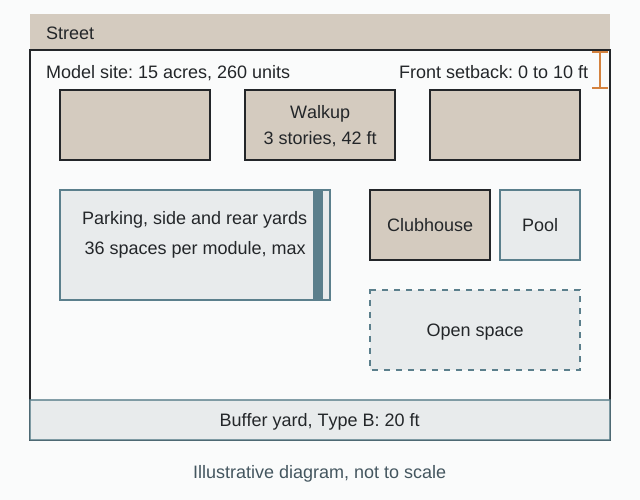
The model starts from a conventional suburban garden walkup: 260 units in 3-story buildings with pitched roofs and exterior stair entries, surface parking, a clubhouse and pool, all residential, on 15 acres. Here is what Knightdale's rules and record do to it.
| Element | As proposed | As the rules shape it |
|---|---|---|
| Approval path | A site plan on multifamily-zoned land | No by-right path: a Conditional District use, so a legislative PUD or CD rezoning with a Master Plan; the approved comparables used NMX PUD [1, 6, 7, 9] |
| Location | Any suitably zoned parcel | Sec. 5.2(A) requires a growth activity center or priority investment area of the KnightdaleNext V.2 2035 Comprehensive Plan [1] |
| Use mix | All residential | Restaurants, retail or services on the ground level with residences above, and 26,000 sq ft of nonresidential space at 100 sq ft per unit (studio arithmetic); multifamily at no more than 40% of net development area under Table 11.1(B) [1, 4] |
| Height | 3 stories | Allowed: 42 ft and 3 stories in UR12 and RMX, 56 ft and 4 stories in NMX; a story is no more than 14 ft floor to floor [1] |
| Density | 260 units on 15 acres | RMX caps density at 18 du/ac, or 270 units on 15 acres (studio arithmetic); NMX has no maximum [4] |
| Roofs | Pitched | Flat roofs screened by parapets (Sec. 6.7) and a predominantly flat appearance (Sec. 5.2(A)(3)), so pitched roofs need a PUD exception [1] |
| Entries | Unit doors on exterior stairs | Common front entrances, with unit entries internal to the building (Sec. 6.7) [1] |
| Facades | Siding | At least 50% brick or stone, and no uninterrupted wall of 20 ft or more visible from a public right-of-way [1] |
| Building placement | Buildings behind a front parking field | Front setback 0 ft minimum and 10 ft maximum, and no parking in the front yard [1] |
| Parking | Surface lots sized to the market | Minimum 1.0 per bedroom up to 2.0 per unit and maximum 1.5 per bedroom up to 3.0 per unit [2]; from January 1, 2027, no minimum count may be required outside the coastal area [3] |
| Parking fields | Long double-loaded rows | Modules of no more than 36 spaces, no space more than 60 ft from a canopy tree, and 300 sq ft of pervious area per canopy tree [2] |
| Open space | Pool, clubhouse and site edges | 580 sq ft x 2.5 bedrooms per unit: 8.65 ac before credits, 6.49 ac after the 25% pool and clubhouse credit (studio arithmetic) [4] |
| Access | One entrance | More than 200 units requires two separate open and functioning access roads [4] |
| Water | Assumed available | 50 Water Allocation points required; multifamily starts with 20 base points [5] |
In the model, the rows that change the building (roofs, entries, facades and the nonresidential share) become the PUD exception table, and the rows that change the land (open space, parking fields and access) set the yield. The open space requirement drops by 25% for the portion of a site within 1/2 mile of improved, publicly dedicated open space, and by 50% within 1/4 mile (Sec. 11.2(C)(1)), and Sec. 11.2(A) says the requirement does not "permit the use of leftover or otherwise unusable land" [4]. A parcel near a Town park or greenway therefore carries more buildable area for the same program [4].
Parking reform lands mid-entitlement. Until January 1, 2027, the UDO minimum governs. From that date, G.S. 160D-702(c)(2a), as amended by S.L. 2026-39, bars requiring "an off-street parking lot to meet a minimum number of parking spaces per development or structure, regardless of occupancy or use," except for local governments in the coastal area defined in G.S. 113A-103, and subdivision (c)(2) caps required stall size at "9 feet wide by 20 feet long" [3]. Knightdale's UDO also caps parking: the maximums may be exceeded only where all parking is in a structure (Sec. 7.1(H)(2)) [2]. For how a minimum converts into lost units, see what a parking minimum costs you.
Site data and yield
The site data table on the preliminary plan carries each line the Town tests. Values marked studio arithmetic are calculations on the cited standards for this 260 unit model.
| Site data line | Model value, or the rule it is tested against | Source |
|---|---|---|
| Gross acreage | 15 acres (model); at RMX's 18 du/ac, 260 units need at least 14.4 ac (studio arithmetic) [4] | Table 11.1(A) |
| Zoning | NMX PUD, the tool of the approved comparables; NMX carries no density maximum [4, 6] | Table 11.1(A); Sec. 6.3(A) |
| Units and bedrooms | 260 units; where building specifications are not known, open space is computed at 2.5 bedrooms per unit [4] | Sec. 11.2(C)(3) |
| Density against the cap | Under RMX's 18 du/ac, 270 units on 15 acres (studio arithmetic); no cap in NMX [4] | Table 11.1(A) |
| Height and stories | 3 stories, at most 42 ft in UR12 and RMX; 56 ft and 4 stories in NMX [1] | Table 3.4 |
| Nonresidential space | 26,000 sq ft at 100 sq ft per unit (studio arithmetic) [1] | Sec. 5.2(A)(2) |
| Recreational open space | 377,000 sq ft (8.65 ac) at 580 sq ft x 2.5 bedrooms per unit before credits; 6.49 ac after the 25% amenity credit (studio arithmetic) [4] | Table 11.2(C)(4); Sec. 11.2(D)(3) |
| Open space share of the site | About 58% of the site before credits, or about 43% after the amenity credit (studio arithmetic) [4] | Sec. 11.2 |
| Amenity credit test | A pool with at least 2,500 sq ft of water surface plus a clubhouse of at least 1,500 sq ft [4] | Sec. 11.2(D)(3) |
| Parking required against provided | Minimum 1.0 per bedroom up to 2.0 per unit; maximum 1.5 per bedroom up to 3.0 per unit; reductions of 5% for cross access and up to 10% within 900 ft of a transit stop; counts follow the unit mix [2] | Sec. 7.1(G)(2), 7.1(H)(1) |
| Bicycle and EV parking | 1 bicycle space per 20 vehicle spaces, up to 100; EV charging at 1 per 40 vehicle spaces, minimum 2 and maximum 10 [2] | Sec. 7.1(F)(1), 7.1(I)(2)(a) |
| Cluster mailbox parking | With 1 box per unit: Max 10; min 5 short-term spaces (studio arithmetic) [1] | Sec. 5.10(B)(3) |
| Access points | Two separate open and functioning access roads above 200 units [4] | Sec. 11.3(E)(6)(b) |
| Tree cover area | Perimeter in feet x 20, up to 10% of the site [2] | Sec. 7.4(M)(2) |
| Water allocation points | 50 required; multifamily earns 20 base points [5] | Water Allocation Policy |
| Town fees | About $91,850 under the FY25 schedule, of which $78,000 is the $300 per unit transportation development fee; excludes consultant review billed at actual cost, Wake County building permits, Raleigh Water fees and state permits (studio arithmetic) [13] | FY25 Rate and Fee Schedule |
Yield in the record. Elevate Riverview works out to about 14.1 du/ac (394 units on about 28 ac), and Parkstone-Dewitt to about 26 du/ac on its residential portion, above the RMX cap and possible because NMX has no maximum (studio arithmetic) [9, 6, 4]. At the model's 15 acres, the open space dedication alone takes more than half of the site before credits (studio arithmetic), so siting near public open space and the pool and clubhouse credit come first in the layout [4]. For the wider arithmetic of a parking-led acre, see everybody counted the parking.
Comparable approvals and withdrawals, 2021 to 2026
Every comparable apartment-heavy PUD in the Town's records for 2021 to 2026 was approved, and one large apartment PUD was withdrawn [6, 7, 8, 9, 29]. The documents cited give no votes, Land Use Review Board tallies or itemized conditions for these cases, so the table states none.
| Case | Program | Outcome | Vote | Conditions | Opposition |
|---|---|---|---|---|---|
| Village Gate Mixed Use (ZMA-1-21) | Mixed-use PUD on about 76 ac, RT to NMX PUD [7] | Approved April 21, 2021 [7] | Not stated | Not stated | Not stated |
| Elevate Riverview at Riverview Commons (ZMA-10-21) | 364 multifamily units plus 30 townhomes on about 28 ac, RMX to NMX PUD; pool, clubhouse, pickleball, dog park and trails [9] | Approved February 16, 2022; construction drawings approved February 2023, revised December 2023 [9] | Not stated | Not stated | Not stated |
| Parkstone-Dewitt Mixed-Use (ZMA-15-21) | 290 multifamily units, a 124-room hotel and 29,200 sq ft of commercial on about 14 ac (about 11 ac east of Parkstone Towne Blvd plus a hotel site), HB-CD to NMX PUD [6] | Approved [6] | Not stated | Not stated | Not stated |
| Union Park (ZMA-13-22) | About 100 apartments, 468 single-family, townhome and condo units, up to 500,000 sq ft of commercial and a community park on about 90 ac, RT to NMX and TC PUD [8] | Approved [8] | Not stated | Not stated | Not stated |
| Boulder Ridge (ZMA-3-24) | About 34.11 ac, HB to NMX-PUD, at Hodge Rd and Old Faison Rd [29]; the documents give two different programs, so none is stated here | Withdrawn by the applicant September 15, 2025 [29] | None | Not applicable | Not stated |
Before the window. The Lofts at Knightdale Station (ZMA-1-20) was approved September 16, 2020 for 195 multifamily units and 12,000 sq ft of retail and office, and its construction drawings were approved June 27, 2024 [15]. Its PUD master plan set documented 66 Water Allocation points, including "Meeting space without kitchen more than 3500 square feet 8" [30]. The ZMA-7-16 staff report of August 17, 2016, for the Suggs/Hargrove project that preceded Parkstone, describes 350 multifamily units in "13 3-story buildings" with a clubhouse, 722 multifamily parking spaces and three wet ponds [31]. Its requested exceptions included "Parking areas will be provided in pods not to exceed 50 parking spaces" and removal of an internal 50-foot Type C buffer, and one resident "was concerned with the number of apartments" [31]. The parking module in today's Sec. 7.1(M)(2) is 36 spaces [2].
Related residential cases, not apartment-led, that show how opposition plays out:
| Case | Program | Outcome | Opposition themes |
|---|---|---|---|
| Creekview Crossing (ZMA-5-21) | 283 units (single-family, townhome and multifamily) on 102 ac, RT to GR3 PUD; a virtual neighborhood meeting on March 17, 2022 drew about 20 neighbors [32] | Approved [32] | Loss of trees and woodland on up to 100 acres; one resident: "The overcrowding worries me... I don't want to turn into Raleigh or Cary" (WRAL) [33] |
| Forestville Village | About 290 residential lots on 53 ac [34] | The LURB forwarded a recommendation of approval [34] | More than 100 residents petitioned over pedestrian safety and traffic, and disputed the virtual public comment format (CBS17) [34, 35] |
| Terravita (ZMA-4-23) | Residential PUD [36] | Continued September 17, 2025; a revised proposal approved November 19, 2025 [36] | Not stated |
Opposition in this record centers on traffic, pedestrian safety, tree loss and "overcrowding" [33, 34]. A withdrawal does not cost a waiting period: S.L. 2025-94 Section 11 provides that a development regulation "may not include waiting periods" on refiling "a denied or withdrawn application for a zoning map amendment, text amendment, development application, or request for development approval" [37]. For how other developers have carried apartment density through hearings, see multifamily zoning approval.
Cost and phasing benchmarks
No market-rate garden hard cost per square foot from a North Carolina primary source is in the documents cited. The benchmarks below come from the state's tax-credit rulemaking record, a national cost study and the Town's fee schedule.
| Benchmark | Figure (market evidence) | Source and date |
|---|---|---|
| Average per-unit development cost, new construction, suburban, Raleigh | $287,980 | City of Raleigh comment letter to NCHFA on the 2026 QAP, October 9, 2025 [38] |
| Average per-unit development cost, new construction, urban, Raleigh | $385,315 | Same letter [38] |
| NCHFA developer fee limit, new construction | $23,000 per unit (2025 QAP) | 2025 QAP, final [39] |
| RSMeans residential location factor, Raleigh | 0.850 | NAHB, Estimated Costs of the 2024 IRC Code Changes [40] |
| Knightdale transportation development fee | $300 per multifamily unit (FY25) | FY25 Rate and Fee Schedule [13] |
| Knightdale payment in lieu of recreation | $2,500 per dwelling unit (FY25) | FY25 Rate and Fee Schedule [13] |
| Stormwater installation security | SCM cost plus 25% | UDO 9.4(H)(4)(b) [18] |
| Stormwater replacement fund | 33% of SCM construction cost | UDO 9.4(H)(9)(a) [18] |
The City of Raleigh and NCHFA figures come from the Low-Income Housing Tax Credit Qualified Allocation Plan record, so they describe tax-credit projects [38, 39]. Two Knightdale layout rules carry cost a contractor will price early: the brick-or-stone facade share of Sec. 6.4(F) and the 10-foot foundation walkways of Sec. 7.3(C) [1, 2]. The site plan cost guide covers what the plan itself costs to prepare.
Phasing rules in the Knightdale record.
| Phase rule | Text | Source |
|---|---|---|
| Water allocation by phase | "Each phase of a phased development must comply with the terms and development schedule of an approved Development Agreement before the next phase can begin" [5] | Water Allocation Policy |
| Allocation expiry | Allocation is lost if there is no progress "for a period of 12 months" [5] | Water Allocation Policy |
| Infrastructure grading | "Grading for infrastructure improvements... shall be phased according to the Master Plan" [18] | UDO 9.3(B)(1) |
| Second access | More than 200 units requires two access roads [4] | UDO 11.3(E)(6)(b) |
| Stormwater devices | The final residential device may be installed "at such point that seventy-five (75) percent or more of the residential lots are completed" [18] | UDO 9.4(G)(8) |
| Vesting | 2 years, up to 5 at Council discretion [1] | UDO 1.7(C)(1)(a) |
The model phases at the access rule. Phase 1 stops at 200 units with every building sprinklered, the largest count Sec. 11.3(E)(6)(b) allows on a single open and functioning access, and the second access road comes with Phase 2 [4]. Site work can start on an approved E&SC plan: under S.L. 2023-142 the local government must allow land disturbance to begin "notwithstanding that other development approvals ... have not yet been obtained" [41].
Submittal anatomy
What each stage asks for, split between what the preliminary plan carries and what the engineer or architect of record adds.
| Stage | What the Town requires | Preliminary plan | Engineer or architect of record |
|---|---|---|---|
| Sketch Plan (UDO 12.3(D)) | A staff courtesy review, billed in the FY23 schedule as "Sketch Plan Review (Site Plan & Subdivision Courtesy Review)" [42] | Layout, buildings, parking, open space, buffers and the density table | Nothing at this stage |
| Stormwater concept (UDO 9.4(C)(1)(b)) | Existing and proposed topography; perennial and intermittent streams; soils; buffers; existing vegetation; limits of clearing and grading; roads, buildings and parking; a natural resources inventory; an SCM concept showing locations, conveyances, floodplain limits and crossings [18] | All the graphic items | SCM sizing and calculations |
| Rezoning and Master Plan | Filed with the WCPSS Residential Development Notification [14]; a TIA where the project generates 150 or more new peak hour trips [4]; the 50 Water Allocation points [5] | Site data table, yield, unit mix, bedroom count, open space and parking calculations, water allocation points and the PUD exception table | The TIA |
| Landscape and lighting (UDO 7.4(D)(1), 7.7(D)(1)) | A landscape plan before site disturbance and a lighting plan with fixtures and foot-candles [2] | Buffer types, tree save areas and the tree cover area | Photometrics and planting schedules |
| Construction drawings (UDO 12.3(G)) | Rolling submittal after the rezoning [17] | No new layout work | Grading, utilities to Raleigh Water standards, the stormwater permit application and the E&SC plan |
| Stormwater permit (UDO 9.4(C)(2)) | A plan prepared by "a qualified licensed North Carolina Professional Engineer or registered surveyor, soil scientist, or landscape architect" [18] | None | Full design, operation and maintenance agreement, performance security |
| Floodplain (UDO 9.5(D)(2)) | Description of the development, SFHA determination, Regulatory Flood Protection Elevation, certification schedule and floodway encroachment statement [18] | SFHA limits on the plan | Elevation certificates and no-rise analysis |
| Close-out (UDO 9.4(C)(5)) | As-builts that "certify, under seal," plus geotechnical surveys, CCTV and GIS files [18] | None | Sealed as-builts |
What a Knightdale PUD book carries. The 2022 PUD books for Haven at Griffith Meadows and Harper Preserve show the content a preliminary plan is expected to hold: a block showing existing and proposed zoning, total project area and proposed density, and a table of requested UDO exceptions with section numbers [43, 44]. The Lofts master plan set put a water allocation points table and utility notes on the plan itself [30]. For the lender's reading of the same sheet, see multifamily site plan anatomy.
Where seals sit. The UDO names sealed work stage by stage: stormwater management plans by an NC PE, surveyor, soil scientist or landscape architect (9.4(C)(2)(a)); sealed stormwater as-builts before the certificate of occupancy (9.4(C)(5)(b)); sealed annual inspections of stormwater control measures (9.4(H)(1)(b)); and floodproofing certificates by a PE or architect (9.5(D)(3)(b)) [18]. Chapter 13 does the same for nonconforming sites: "Property owners shall submit a site plan signed and sealed by a professional engineer or landscape architect licensed in North Carolina" [45]. The documents cited do not settle whether a rezoning Master Plan must be sealed; confirm it at the pre-application meeting. At the state level, G.S. 89C-25 says the engineering act "shall not prevent ... (1) The practice of architecture as defined in Chapter 83A of the General Statutes, landscape architecture as defined in Chapter 89A of the General Statutes, or contracting" [46]. The preliminary plan is the concept the engineer of record builds the sealed set on; see preliminary vs final site plan and where unsealed site plans are accepted.
Conditions and handoff
The documents cited give no itemized zoning conditions for the 2021 to 2026 apartment approvals. They do show where the Town rewards a plan for going past the UDO minimum, and what the engineer of record takes over.
- Architecture earns utility allocation. The Village Gate UAA staff report awarded 15 Water Allocation bonus points for "Residential Architectural Standards for House & Townhouse Ch. 5" [47]. Sec. 6.4(F)(1) requires that "Buildings shall be designed in compliance with four-sided design standards" [1].
- Architecture can also be offered at zoning. In the approved Hopkins Farm PUD document (9.24.2025), a case outside the comparable set above, "The applicant has offered tailored architectural standards for these units as a condition of the zoning approval" [48].
- Amenities earn points. The Lofts plan counted "Meeting space without kitchen more than 3500 square feet 8" among its 66 Water Allocation points [30].
- Affordability earns points. The Affordable Knightdale Plan (adopted March 20, 2024) recommends adding zoning incentives to the UDO [49], and the Water Allocation Policy awards 10 bonus points to "Implement recommendations of the Affordable Knightdale Plan" [5].
Elevations that show the masonry share, the facade breaks and the parapet line are how a plan demonstrates Sec. 6.4(F), 6.4(G) and 6.7 at the hearing [1]. Tying those elevations to the site plan is the job of apartment renderings and 3D renderings.
At 15 acres the model sits inside both state construction thresholds: NCG010000 "applies to all owners or operators of stormwater discharges associated with construction activities" that disturb land "greater than or equal to one acre" [50], and the E&SC plan "must be submitted at least 30 days before land disturbance begins on any site involving over one acre" [19]. For streets and drives, S.L. 2025-94 Section 4 bars pavement design standards stricter than NCDOT's for projects initiated on or after January 1, 2026 [37].
At handoff the engineer of record takes the approved Master Plan and its PUD exceptions and adds grading, utilities to Raleigh Water standards, the SCM design and stormwater permit, the E&SC plan, the TIA, floodplain certifications and the sealed as-builts [18, 22]. The preliminary plan supplies the layout, the site data table, the open space and parking arithmetic, the water allocation points and the exception table that the hearing reads; the parking reform that changes the minimum from 2027 is tracked in multifamily parking reform by state.
Frequently asked questions
Can I build garden apartments by right in Knightdale?
How many units fit on 15 acres in Knightdale?
Can a garden walkup in Knightdale have pitched roofs?
Not by right. Three stories and 42 ft are allowed in UR12 and RMX (Table 3.4), but the Apartment Building Type requires flat roofs with parapets (Sec. 6.7) and Sec. 5.2(A)(3) requires a predominantly flat appearance, so pitched roofs need a PUD exception [1].
How much parking does a Knightdale apartment project need?
The UDO sets a minimum of 1.0 space per bedroom up to 2.0 per unit and a maximum of 1.5 per bedroom up to 3.0 per unit, with reductions of 5% for cross access and up to 10% near transit (UDO 7.1) [2]. From January 1, 2027, S.L. 2026-39 bars a local government from requiring a minimum number of spaces outside the coastal area [3].
How much open space must a Knightdale apartment community dedicate?
500 to 580 sq ft per bedroom outside 1/2 mile of a public park, at 2.5 bedrooms per unit by default, less 25% for a pool with at least 2,500 sq ft of water surface plus a clubhouse of at least 1,500 sq ft (UDO 11.2) [4].
Do I need a traffic study in Knightdale?
How do I secure water and sewer in Knightdale?
How many entrances does a 260 unit community need?
Two. Above 200 units, Sec. 11.3(E)(6)(b) requires 'two separate open and functioning vehicular access roads,' regardless of sprinkler systems [4].
Sources
- 1)Knightdale Unified Development Ordinance (adopted July 21, 2021; consolidated edition dated 05/2026), Town of Knightdale, North Carolina. Accessed 2026-10-10.
- 2)Knightdale UDO Chapter 7, Development Standards (file dated 05/22/26), Town of Knightdale, North Carolina. Accessed 2026-10-10.
- 3)Session Law 2026-39 (House Bill 162), North Carolina General Assembly. Accessed 2026-10-10.
- 4)Knightdale UDO Chapter 11, Subdivision Standards (file dated 05/22/26), Town of Knightdale, North Carolina. Accessed 2026-10-10.
- 5)Municipal Water Allocation Policy, 2024 update, Town of Knightdale, North Carolina. Accessed 2026-10-10.
- 6)Parkstone-Dewitt Mixed-Use (ZMA-15-21), project page, Town of Knightdale, North Carolina. Accessed 2026-10-10.
- 7)Village Gate Mixed Use (ZMA-1-21), project page, Town of Knightdale, North Carolina. Accessed 2026-10-10.
- 8)Union Park (ZMA-13-22), project page, Town of Knightdale, North Carolina. Accessed 2026-10-10.
- 9)Elevate Riverview at Riverview Commons (ZMA-10-21), project page, Town of Knightdale, North Carolina. Accessed 2026-10-10.
- 10)Session Law 2025-30 (House Bill 173), North Carolina General Assembly. Accessed 2026-10-10.
- 11)KnightdaleNext V.2 2035 Comprehensive Plan update, Town of Knightdale, North Carolina. Accessed 2026-10-10.
- 12)Planning and Zoning Law Bulletin No. 36 (February 2026), UNC School of Government. Accessed 2026-10-10.
- 13)FY25 Rate and Fee Schedule, amended 1-15-2025, Town of Knightdale, North Carolina. Accessed 2026-10-10.
- 14)Rezoning Process, Town of Knightdale, North Carolina. Accessed 2026-10-10.
- 15)The Lofts at Knightdale Station Mixed Use (ZMA-1-20), project page, Town of Knightdale, North Carolina. Accessed 2026-10-10.
- 16)Instructions for the NCDOT TIA Checklist, North Carolina Department of Transportation. Accessed 2026-10-10.
- 17)Administrative Approval Process, Town of Knightdale, North Carolina. Accessed 2026-10-10.
- 18)Knightdale UDO Chapter 9, Environmental Protection Standards (file dated 03/15/23), Town of Knightdale, North Carolina. Accessed 2026-10-10.
- 19)Report to the North Carolina General Assembly: Study of Erosion and Sedimentation Applicable to Storm Water Discharges from Construction Activities, North Carolina Department of Environmental Quality. Accessed 2026-10-10.
- 20)15A NCAC 02B .0714, Neuse River Basin riparian buffer rule, North Carolina Office of Administrative Hearings. Accessed 2026-10-10.
- 21)Utility Permits, Town of Knightdale, North Carolina. Accessed 2026-10-10.
- 22)Raleigh Water Public Utility Design Manual, effective 01-18-2025, City of Raleigh, North Carolina. Accessed 2026-10-10.
- 23)Policy on Street and Driveway Access to North Carolina Highways (July 2003), North Carolina Department of Transportation. Accessed 2026-10-10.
- 24)Driveway Permit Frequently Asked Questions, North Carolina Department of Transportation. Accessed 2026-10-10.
- 25)Street and Driveway Access Permit Application, North Carolina Department of Transportation. Accessed 2026-10-10.
- 26)G.S. 160D-1110.1, Commercial and multifamily building permits, North Carolina General Assembly. Accessed 2026-10-10.
- 27)Development Guide, Town of Knightdale, North Carolina. Accessed 2026-10-10.
- 28)Project List, Town of Knightdale, North Carolina. Accessed 2026-10-10.
- 29)Boulder Ridge (ZMA-3-24), project page, Town of Knightdale, North Carolina. Accessed 2026-10-10.
- 30)PUD Master Plan, The Lofts at Knightdale Station (full set), Town of Knightdale, North Carolina. Accessed 2026-10-10.
- 31)Staff Report, ZMA-7-16 (August 17, 2016), Town of Knightdale, North Carolina. Accessed 2026-10-10.
- 32)Creekview Crossing (ZMA-5-21), project page, Town of Knightdale, North Carolina. Accessed 2026-10-10.
- 33)Knightdale residents fight back on rezoning, Creekview Crossing (news report), WRAL. Accessed 2026-10-10.
- 34)Proposed Knightdale development moves to town council despite opposition from some residents (news report), CBS17. Accessed 2026-10-10.
- 35)Knightdale residents say the town is muzzling ways to speak out against rezoning (news report), CBS17. Accessed 2026-10-10.
- 36)Terravita (ZMA-4-23), project page, Town of Knightdale, North Carolina. Accessed 2026-10-10.
- 37)Session Law 2025-94, Regulatory Reform Act of 2025, North Carolina General Assembly. Accessed 2026-10-10.
- 38)City of Raleigh comment on the 2026 Qualified Allocation Plan (October 9, 2025), City of Raleigh Housing and Community Development Department (via North Carolina Housing Finance Agency). Accessed 2026-10-10.
- 39)2025 Low-Income Housing Tax Credit Qualified Allocation Plan, final, North Carolina Housing Finance Agency. Accessed 2026-10-10.
- 40)Estimated Costs of the 2024 IRC Code Changes, National Association of Home Builders. Accessed 2026-10-10.
- 41)Senate Bill 677 (S.L. 2023-142), ratified bill, North Carolina General Assembly. Accessed 2026-10-10.
- 42)FY23 Town of Knightdale Fee Schedule, Town of Knightdale, North Carolina. Accessed 2026-10-10.
- 43)Haven at Griffith Meadows PUD book (2022), Town of Knightdale, North Carolina (project file). Accessed 2026-10-10.
- 44)Harper Preserve PUD book (2022), Town of Knightdale, North Carolina (project file). Accessed 2026-10-10.
- 45)Knightdale UDO Chapter 13, Nonconformities, Town of Knightdale, North Carolina. Accessed 2026-10-10.
- 46)G.S. 89C-25, Limitations on application of Chapter, North Carolina General Assembly. Accessed 2026-10-10.
- 47)Village Gate Utility Allocation Agreement, staff report, Town of Knightdale, North Carolina. Accessed 2026-10-10.
- 48)Hopkins Farm approved PUD document (9.24.2025), Town of Knightdale, North Carolina (project file). Accessed 2026-10-10.
- 49)Affordable Knightdale Plan, Town of Knightdale, North Carolina. Accessed 2026-10-10.
- 50)NPDES General Permit NCG010000, Stormwater Discharges Associated with Construction Activities, North Carolina Department of Environmental Quality. Accessed 2026-10-10.