A model project in a county with its own campground code
This is a model project: a 60 to 120 site campground with 10 to 20 camp cabins on a 20 to 80 acre parcel in unincorporated Chaffee County, Colorado, used to show how the county's code and the state's rules shape a preliminary site plan. It is not a built or commissioned project.
Chaffee County publishes campground-specific standards in LUC Sec. 2.2.2.4.B. Its Land Use Code was adopted 11-19-2024 by Resolution 2024-78 and took effect 1-1-2025 [1, 5]. On that date campgrounds moved from Limited Impact Review under the old code to a Conditional Use heard by the Board of County Commissioners (BOCC) [6]. The county also posts a version of the code amended 9-16-2025 [7].
The answer for this program in one paragraph: a campground of this size is buildable only as a Conditional Use decided by the BOCC after a public hearing, in the AR, RR, MUR or MUC districts, never by right, and capped at 20 campsites or camp cabins per acre [1]. At 50 gpd per campsite under Regulation 43 Table 6-2, 60 sites produce 3,000 gpd and 120 sites 6,000 gpd, both above the 2,000 gpd threshold for state site location and design approval [4]. At the Pine Creek campground hearing in June 2026, commissioners denied the permit on demonstrated need and wildlife mitigation although staff had recommended approval, as The Mountain Mail reported [8].
The design method follows the campground site plan hub. The statewide layer is on the Colorado site plan page and the Colorado campground site plan page, and the Colorado RV park site plan page covers the RV side of the same state rule. State campground rules are compared in glamping and campground regulations by state.
At a glance
| Item | Model project | Source |
|---|---|---|
| Asset | Developed or modern campground as defined in 6 CCR 1010-9 Sec. 2.10, with RV sites, tent sites, 10 to 20 camp cabins and service buildings | [1, 2] |
| Program (model assumption) | 60 to 120 sites including 10 to 20 camp cabins; office, bathhouse and laundry; sanitary waste station | Model |
| Parcel (model assumption) | 20 to 80 acres | Model |
| Code minimum gross area | 3 acres (60 units) to 6 acres (120 units) at the 20 per acre cap; realistic gross area is materially larger once residential-edge setbacks, OWTS fields, augmentation and drainage areas, and resource setbacks are applied | [1] |
| Jurisdiction | Unincorporated Chaffee County; sites inside the Salida or Buena Vista IGA areas also follow those IGAs (LUC Sec. 1.2.1.6) | [1] |
| How the use is allowed | Conditional Use ("C", public hearing) in AR, RR, MUR, MUC and PCR; prohibited in RS, RM and IN; no by-right path in any district (Table 2.1.3.4) | [1] |
| Best-fit district | MUR, whose stated purpose names campgrounds (Table 2.1.2.2, quoted below) | [1] |
| PCR limit | Primitive, semi-primitive or semi-developed formats only, at no more than 10 campsites per acre | [1] |
| Alternative routes | Rezoning ($2,500) into MUR or MUC, or a Planned Development (Conceptual PD $5,000 + $80 per unit) | [3] |
| Cabins sized like lodging | Rural Resort is a separate Conditional Use in RM, MUR and MUC, with a FAR cap of 0.05 in MUR; a combined program is evaluated independently for each listed use (Sec. 2.1.3.14) | [1] |
| Not applicable | Camping on Private Land: administrative, 5-acre minimum, up to 5 sites under 100 acres, $320 fee; a small-scale use that does not fit this program | [3, 9] |
Every eligible district marks the use "C", so the project is decided at a discretionary BOCC hearing under the general review standards of LUC Sec. 2.2.1.3.B, including the need standard quoted below [1]. Variations to the use standards of Division 2.2.2 may be approved where the variation substantially meets the purpose of the standard, with respect to mitigation of impacts, and the review standards (Sec. 2.2.1.3.C) [1].

Approval path
Every approval in order, with the body, the code section, the published fee and clock, and whether a sealed submittal is required. "Not stated" means the record retrieved does not publish the value.
| Approval, in order | Body | Code section | Stage | Fee | Timeline | Seal |
|---|---|---|---|---|---|---|
| Pre-application conference | Community Planning and Natural Resources Department [10] | Appendix A Sec. 1.A | Concept | No fee | Staff summary within 8 business days; valid about 6 months | No: letter of intent and conceptual site plan [11] |
| Neighborhood meeting, required for a Conditional Use Permit | Applicant | LUC Sec. 5.2.5.3; Appendix A Sec. 1.B | Before CUP filing | Not stated | Not stated | No [10] |
| Conditional Use Permit | BOCC, public hearing | LUC Table 2.1.3.4; Sec. 2.2.1.3; Sec. 2.2.2.4.B | Entitlement | $7,500 plus consultant escrow [3] | Completeness 12 business days; technical sufficiency 16 business days; applicant response 12 business days; notice 15 days before the hearing [11] | Septic suitability report by a Colorado PE; other studies by qualified professionals [11] |
| Site plan or zoning permit | Planning staff | LUC Sec. 5.2.3.2; Zoning Permit Instructions | Post-entitlement | $800 [3] | Not stated | Civil engineering plans for parking, drainage and utilities [12] |
| Subdivision or plat, only if land is divided or leased pads are platted | BOCC or staff | LUC Div. 5.2.6, 5.2.7 | If needed | Minor Subdivision $2,000 + $80 per lot [3] | Varies | Plat by a Colorado PLS [11] |
| Water supply report and commercial well permit | County Engineer (report, LUC Sec. 4.3.2.5.B.2); Colorado Division of Water Resources, Division 2 (well) | Water supply standards | Entitlement and construction | UAWCD lists a $100 new well permit fee; DWR fee not stated [13] | Not stated | Report by a "County approved licensed water engineer, geologist, or hydrologist" [14] |
| Augmentation | UAWCD blanket plan (decree 92CW84, Division 2 water court) or a project-specific water court decree | UAWCD plan; water court | Before the well permit | $200 application; $3,850 per 0.10 AF unit; $165 per unit annually [13] | Not stated | Not stated [15] |
| State site location and design approval for a system over 2,000 gpd | CDPHE Water Quality Control Division | 5 CCR 1002-43 Sec. 43.4; C.R.S. 25-8-702; 5 CCR 1002-22 | Entitlement and design | Not stated | Not stated | Engineered design by a PE [4] |
| County OWTS permit | Chaffee County Building Safety, under BOH Resolution 2018-02 and Regulation 43 | Reg. 43 Sec. 43.4; LUC Sec. 4.3.3.2 | Construction | Not stated; BOH variance $50 [16] | Not stated | Septic suitability report by a Colorado PE [11] |
| Drainage, grading, erosion and sediment control | County Engineer | LUC Sec. 4.2.3, 4.2.4 | Site plan | Included | GESC plan when more than 1 acre is graded | Preliminary drainage report signed by a Colorado PE [14] |
| State highway access (US 285, US 24 or other state highway frontage) | CDOT Region access unit | 2 CCR 601-1 | Entitlement and construction | $50 (Level 1), $100 (Level 2), $300 (Level 3 with roadway improvements) [17]; no fee at application, collected if the permit is issued [18] | Not stated | Traffic assessment per the CDOT guidelines; signed and sealed completion certification on permits with improvements [19] |
| County road access | Road and Bridge | LUC Ch. 3.2; fee schedule | Access | $160 ROW or Driveway Permit [3] | Not stated | Driveway grade certification by a PLS, PE or architect [11] |
| Floodplain or hazard development permit; fluvial hazard assessment | Staff and County Engineer | LUC Sec. 5.2.3.1; Div. 3.7.4 | If in a flood or fluvial zone | $160 [3] | Not stated | Assessment by a qualified fluvial morphologist, geologist, hydrologist or engineer [14] |
| 1041 permit, only if a major new domestic water or sewage treatment system or a new community is triggered | BOCC as Permit Authority | Chaffee 1041 Regulations Ch. 2, 4, 5, 8 | Parallel | $5,000 deposit plus cost basis plus 10% [3, 20] | Not stated | Plans by a registered professional engineer, architect or other appropriate professional (Sec. 2-203(3)(b)) [20] |
| Fire protection report; fire protection plan (IWUIC Sec. 405); defensible space plan (IWUIC Sec. 603, 604) | Fire protection district; Director | LUC Sec. 4.1.3.1 to 4.1.3.3 | With the CUP and site plan | Not stated | Not stated | Not stated [11] |
| Building permits: cabins (a permit "may be required"), bathhouse and office | Building Safety | LUC Sec. 2.2.2.4.B.3.h.ii; Ordinance 2023-02 (2015 IBC, IRC, IFC, IECC 2006 as amended) | Construction | Not stated | Not stated | Not stated [1, 21] |
| State campground standards | Enforced by CDPHE, CPW, State Parks, county and district health departments (C.R.S. 25-13-111) | 6 CCR 1010-9 | Design and operation | Not stated | N/A | No [2] |
| Appeal or variance, if needed | BOCC | Fee schedule | As needed | Appeal $2,500, refunded if successful; Variance $1,250 [3] | N/A | N/A |
| Final inspections and certificate of occupancy | Building Safety; third-party IWUIC verification of defensible space and driveways | Appendix A IWUIC guide | Close-out | Not stated | Not stated | As-builts by a PE where improvements are secured [11] |
The county publishes its review clocks, and they are short. The record retrieved publishes no duration for state wastewater approval or for augmentation, and the CUP hearing record asks for both, so the model project starts the state wastewater application and the augmentation enrollment alongside the CUP application. The four core county fees total $8,620 (CUP $7,500, site plan $800, floodplain $160, driveway $160) before consultant escrow under Sec. 5.2.5.5, recording and referral fees [3].
Design standards
The numeric standards that shape the layout, county first, then state. The county figures are from the adopted Land Use Code effective 1-1-2025 [1].
| Standard | Value | Citation |
|---|---|---|
| Density, county (AR, RR, MUR, MUC) | 20 campsites or camp cabins per acre, in the aggregate | LUC Sec. 2.2.2.4.B.3.f [1] |
| Density, county (PCR) | 10 campsites per acre | LUC Sec. 2.2.2.4.B.2.b [1] |
| Density, state | 25 campsites per acre excluding roads, buildings and other common use areas | 6 CCR 1010-9 Sec. 5.4 [2] |
| Minimum campsite area | 900 sq ft | 6 CCR 1010-9 Sec. 5.3 [2] |
| RV and cabin sites | 100 ft from property lines adjoining private land in a residential district; 50 ft from a ditch easement edge or 75 ft from its centerline, unless the ditch owner approves less; 25 ft from roads or access easements; 20 ft from side and rear lines; 20 ft from other campsites, buildings and structures; 10 ft from internal roads and drives | LUC Sec. 2.2.2.4.B.3.e [1] |
| Tent sites | 100 ft from residential-zoned private land; 100 ft from a river or stream edge, or more to avoid floodplains and fluvial hazard areas; the 50 ft or 75 ft ditch rule; 50 ft from side and rear lines; 25 ft from roads and access easements; 20 ft from other campsites and structures | LUC Sec. 2.2.2.4.B.1 [1] |
| Camp cabins | 20 ft from all roads and drives; permanent foundation or treated timbers, anchored for wind; fire alarm with battery backup and an extinguisher in each | LUC Sec. 2.2.2.4.B.3.h [1] |
| Format and frontage | Designed as a developed or modern campground; vehicular access to, and frontage along, a public road | LUC Sec. 2.2.2.4.B.3.a, b [1] |
| Site identification | Single address; each cabin, RV and tent space signed at least 6 in square with 4 in numbers; an on-site attendant at all times | LUC Sec. 2.2.2.4.B.3.c, d [1] |
| State spacing | Campsite 25 ft from public highway right-of-way; unit 3 ft from the campsite lot line; units 10 ft from buildings and units on adjacent sites | 6 CCR 1010-9 Sec. 5.2, 5.10, 5.11 [2] |
| Site access | 10 ft clear where a site does not front a road | 6 CCR 1010-9 Sec. 5.5 [2] |
| Internal roads, state | Entrance 24 ft unless there is a separate exit; one lane 10 ft; two lanes 20 ft; parallel parking lane 10 ft; 13 ft overhead and 3 ft side clearance; dead ends need a 50 ft turnaround, Y or T; at least two means of access to the entrance | 6 CCR 1010-9 Sec. 4.3, 4.4 [2] |
| Roads, county | Local road 60 ft ROW, 11 ft lanes, 2 ft shoulders, gravel; max grade 8% local, 2% within 50 ft of an intersection; grades over 5% need a PE drainage plan; cul-de-sac radius 45 ft; commercial two-way driveway 24 ft minimum | Engineering Criteria Manual [14] |
| Secondary access | Required for parcels larger than 10 acres | Appendix A [11] |
| Fire apparatus access | 14 ft clear width, 14 ft clear height; turnarounds beyond 150 ft; turnouts 10 ft x 30 ft every 400 ft; driveway average grade 8% max unless the Fire Code Official approves more | IWUIC 403.2.1, 403.2.2, 403.2.5, 403.7.2 as amended [11] |
| Parking | At least 1 space per campsite (state); county ratio not stated | 6 CCR 1010-9 Sec. 4.5 [2] |
| Water supply | 100 gpd per site with hookups; 75 gpd with common faucets and flush toilets; 50 gpd with privies; 20 psi minimum and 1 gpm per outlet | 6 CCR 1010-9 Sec. 6.5, 6.6 [2] |
| Sanitary facilities | Dependent units and tents: 1 toilet and 1 lavatory per sex per 15 campsites, 1 shower per sex per 30 campsites; self-contained only: 1 per sex per 100 campsites; service building 10 to 400 ft from dependent sites; hot water 3 gal per hour per campsite | 6 CCR 1010-9 Sec. 12.3, 13.1, 13.17 [2] |
| Water and dump stations | Water fill station 1 per 100 campsites, at least 50 ft from the sanitary station; sanitary dump station 1 per 100 campsites without sewer hookups, at least 50 ft from a campsite; common faucets within 150 ft of any campsite | 6 CCR 1010-9 Sec. 6.9, 6.12, 8.10 [2] |
| Utility separation | Water and sewer 10 ft apart horizontally and 2 ft vertically at crossings | 6 CCR 1010-9 Sec. 8.1 [2] |
| Refuse | 60 gal per 5 campsites, within 300 ft of sites; wildlife-resistant containers | 6 CCR 1010-9 Sec. 9.2; LUC [2, 1] |
| OWTS design flow | 50 gpd per campsite | 5 CCR 1002-43 Table 6-2 [4] |
| Lighting | Fully shielded over 500 lumens and DarkSky-compliant; under 2,700 K; poles 20 ft max; path lights 36 in max; parking 10 fc max and 1 fc average; motion lights off within 5 minutes | LUC Div. 3.9.2 via Appendix A Sec. 7.k [10] |
| Slope mapping | 2 ft contours; slopes of 15% to 30% and over 30% flagged; ridgeline protection area 100 ft each side of a crest | Appendix A [11] |
| Landscaping | No nonfunctional turf, artificial turf or invasive plants on commercial property from Jan 1, 2026 (C.R.S. 37-99) | LUC Sec. 3.5.2 via Appendix A Sec. 7.j [10] |
| Stormwater detention | Post-development peak not to exceed pre-development for the 2-yr and 25-yr 24-hr storms; safe passage of the 100-yr; 40-hr drain time for the 2-yr storm | Engineering Criteria Manual [14] |
The provisions that bind the layout, in their own words:
"The campground or RV park shall not include more than 20 campsites or camp cabins (measured in the aggregate) per acre;" (LUC Sec. 2.2.2.4.B.3.f) [1]
"All camp cabins shall be set back 20 feet from all roads and drives" (LUC Sec. 2.2.2.4.B.3.h) [1]
The MUR district's stated purpose names "recreation companies, campgrounds, and hospitality activities in rural areas" (Table 2.1.2.2). [1]
"There is a demonstrated need in the County for the conditional use to serve demands created by County residents, ranches, agricultural operations, visitors, or non-agricultural organizations or businesses." (LUC Sec. 2.2.1.3.B.6) [1]
"Each campsite shall provide at least 900 square feet of space." "The density of campsites shall not be more than 25 campsites per acre excluding roads, buildings, and other common use areas." (6 CCR 1010-9 Sec. 5.3 to 5.4) [2]
"The site shall not be located in an area subject to periodic flooding" (6 CCR 1010-9 Sec. 3.2) [2]
The county spacing rule is the stricter one: 20 ft between sites against the state's 10 ft between units [1, 2]. The county cap of 20 per acre counts the whole site, while the state's 25 per acre excludes roads, buildings and common areas, so the county figure is the one the site data table reports against [1, 2]. The plan tests yield against three limits together: that cap, the 100 ft edge setback where the parcel adjoins residential-zoned land, and the 20 ft spacing between sites. For how these caps compare with other states, see RV sites per acre.
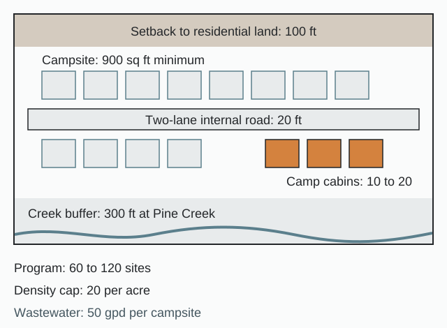
Determination: the program as proposed and as resized
As proposed: 60 to 120 sites including 10 to 20 camp cabins, mixed RV full-hookup and tent sites, with an office, bathhouse and laundry, in the MUR district.
As constrained by code and site:
- Use and hearing. No district allows the program by right. The project stands or falls at the BOCC hearing, where unfulfilled demonstrated need and inadequate wildlife mitigation were the reasons a commissioner gave in the Pine Creek denial, with the creek setback in dispute [1, 8, 22].
- Land. At 20 per acre the code minimum is 3 acres for 60 units and 6 acres for 120 units. The realistic gross area is materially larger once residential-edge setbacks, OWTS fields, augmentation and drainage areas, and resource setbacks are applied [1].
- Wastewater. 60 sites produce 3,000 gpd and 120 sites 6,000 gpd at 50 gpd per campsite, both above 2,000 gpd, which triggers site location and design approval under C.R.S. 25-8-702 and a hydrologic analysis [4]. CDPHE adopted an updated Regulation 43 on 3/10/2025, effective 6/15/2025, and counties have up to 12 months to adopt conforming local rules [23]; the county's Building Safety page records local adoption of the 2017 regulation on Oct 1, 2018 [24].
- Water. The Arkansas basin is over-appropriated, so new non-exempt wells must replace out-of-priority depletions through an augmentation plan [13, 25]. The state's well permit data dictionary lists "Commercial: Ordinary non-manufacturing business such as hotels, campgrounds" [26]. An exempt domestic well was contested at Aspire under DWR Policy 2011-3, so the model plans a commercial well with augmentation [27]. UAWCD's Blue Line "covers most areas in Chaffee County and western Fremont County"; outside it, a project-specific water court decree is needed [13].
- Floodplain and creeks. No sites in an area subject to periodic flooding [2]. The FEMA study includes approximate Zone A studies (2013) on Cottonwood Creek, Browns Creek and others [28]. Any development in a Fluvial Hazard Zone triggers a fluvial hazard assessment, and county mapping is by UAWP and a consultant [14, 29]. On riparian parcels, the 300 ft high-water-mark setback reported at Cottonwood Creek and Pine Creek, and CPW's 500 ft recommendation at Pine Creek, can remove the most marketable riverfront sites [30, 22].
- Scenic and wildlife. Protected vantage points include "Views from the Arkansas River" and U.S. 285 between Chalk Creek and C.R. 150, with a visual impact analysis required where the site is visible (3.6.8.2); a wildlife habitat report by a qualified biologist in consultation with CPW is required where habitat is mapped (3.6.3.4) [11].
Resized for the model: entitle the full 60 to 120 site build-out at the hearing with every phase drawn; Phase 1 carries the water, OWTS and access backbone with a first loop of sites and the service building; Phase 2 sites and cabins follow as augmentation units and wastewater capacity are secured [13, 4].
Design notes for the model project
- Zone first. The model sites the program in MUR, whose purpose names campgrounds, or on AR or RR land where no residential-zoned neighbor sits within the 100 ft setback of the program edge [1].
- Water buffers before sites. The plan draws the river edge, floodplain and fluvial hazard limits first, then a working buffer at the 300 ft code setback reported for Pine Creek, and tests a 500 ft line against CPW's recommendation there; sites are fitted afterwards [1, 22].
- A need case in the packet. The CUP narrative documents demonstrated need under Sec. 2.2.1.3.B.6 with occupancy data and public-land camping pressure, because unfulfilled need was the first reason Commissioner Wood gave for the Pine Creek denial [1, 8].
- Agency letters before submittal. CPW and the fire district are consulted before filing and their letters go in the application; CDOT access is settled early, since a commissioner faulted the missing CDOT access permit at Pine Creek [11, 8].
- State wastewater and augmentation from day one. The program budget carries a CDPHE OWTS site application and a UAWCD or decreed augmentation plan [4, 13].
- Transparent phasing. The full build-out is drawn at entitlement so that phasing cannot be read as hidden expansion; at Agastache Village, neighbors read "phases" as hiding "hundreds more RV sites" [31].
Site data and yield
The preliminary plan carries this table on the sheet, with the cap, the setbacks and the utility loads stated against the program.
| Site data item | Value for the model | Source |
|---|---|---|
| Program | 60 to 120 sites including 10 to 20 camp cabins (model) | Model |
| Zoning | MUR (Conditional Use) | [1] |
| Density allowed | 20 per acre aggregate (county); 25 per acre net of roads, buildings and common areas (state) | [1, 2] |
| Code minimum gross area | 3 acres for 60 units; 6 acres for 120 units | [1] |
| Minimum campsite | 900 sq ft | [2] |
| Parking required | 1 space per campsite minimum (state) | [2] |
| Wastewater design flow | 50 gpd per campsite: 3,000 gpd at 60 sites; 6,000 gpd at 120 sites | [4] |
| Water design flow | 100 gpd per site with hookups; 75 gpd with common faucets and flush toilets | [2] |
| Toilets and showers | 1 toilet and 1 lavatory per sex per 15 dependent campsites; 1 shower per sex per 30 | [2] |
| Water fill and dump stations | 1 per 100 campsites each | [2] |
| Hot water | 3 gal per hour per campsite | [2] |
| Refuse | 60 gal per 5 campsites | [2] |
Two local reference points for yield: Aspire Tours on the Arkansas River was approved for 10 campsites and 7 cabins with a 72-person capacity [32, 33], and the Applejack RV Park notice proposed 29 RV-only spaces in two phases near Salida [34].
Comparable approvals and denials, 2021 to 2026
| Project | Date and body | Program | Outcome and vote | Conditions or reasons |
|---|---|---|---|---|
| Aspire Tours, 11302 CR 190 W, Salida (Arkansas River, north of Big Bend; Limited Impact Review under the old code) | Planning Commission, then BOCC on appeal, April 12, 2022 | 10 campsites, 7 cabins, an outfitting facility and a seasonal employee campground; 72 capacity [32, 33] | Approved by the Planning Commission 6-1 with 41 conditions; the BOCC unanimously denied the appeal and upheld the approval with minor modifications to the conditions [33, 35] | CR 190W traffic mitigation to be negotiated in 90-120 days; phased tree planting for visual screening; findings on campground hours, the operation plan, future floodplain permits and well augmentation [33, 36] |
| Applejack RV Park, 8509 CR 250, Salida (Limited Impact Review under the old code, Rural zone) | Planning Commission hearing April 5, 2022 | 29 RV-only spaces in two phases, a commercial well, two OWTS [34] | The park operates 29 full-hookup sites, per the operator [37] | Not stated |
| Buena Vista Overlook Campground, CR 303 | June 11, 2024, BOCC | 30,000-gallon cistern because the existing well produces nonpotable water | Approved, unanimous, as reported by The Mountain Mail [38] | Civil-engineered drainage plan "with specific attention to mitigate impacts from flooding and water quality impacts of downstream neighbors"; improve neighbor relations before any expansion, as reported by The Mountain Mail [38] |
| Cottonwood Creek setback request | 2026, Board of Adjustment | Reduce the 300 ft high-water-mark setback minimum to 100 ft | Staff's denial stood when the board deadlocked, as reported by the Chaffee County Times [30] | Planner Nick Gomer described the request as one "to reduce the historic high water mark setback minimum from 300 feet to 100 feet," as reported by the Chaffee County Times [30] |
| Ramble Outdoors, Pine Creek, CR 388 (State Land Board lease, north of Buena Vista) | June 9, 2026, BOCC | Campground Conditional Use Permit under the new code | Denied, unanimous, after more than three hours of discussion including 19 public commenters, as reported by The Mountain Mail [8] | Staff recommended approval with 10 conditions; reasons stated were unfulfilled demonstrated need, inadequate wildlife mitigation and the absence of a CDOT access permit; the applicant asked for 100 ft creek setbacks where the code requires 300 ft and CPW recommended 500 ft, as reported [8, 22] |
Before this window, Agastache Village (15 tiny home and RV units on 18.54 acres on CR 146) was denied unanimously by the Planning Commission, and the BOCC rejected the appeal on April 3, 2019 [31, 39]. On June 7, 2022 the BOCC unanimously adopted Resolution 2022-41, a temporary moratorium on certain land use applications, initially through Dec 31, 2022 [40]. When the new code took effect on Jan 1, 2025 the moratorium was lifted [6]. The code now lets the BOCC impose future moratoria "for a period not to exceed 32 months" (LUC Sec. 1.2.2.2) [1].
The Pine Creek record, as reported, shows that a staff recommendation of approval did not carry the hearing. The Chaffee County Times reported that "Every public commenter, both in person and virtually, opposed the permit," and listed opposition themes of wildlife migration, wildfire, creek setbacks, egress access, highway access and impacts to the Pine Creek trailhead [22]. Ark Valley Voice reported three of the ten staff conditions (no fire pits, CPW's 500 ft setback and an operating season of May 1 through Labor Day) and that CPW advises seasonal campground closure from September through November [41]. The Planning Director has described resource setbacks of "anywhere between 50 feet and 300 feet, depending on the lay of the land," as reported by the Chaffee County Times [42].
Aspire drew a petition of "Over 600 county residents" and objections over river trash, agricultural character, pronghorn use of the property to reach the Arkansas River, water supply and road safety; one opponent argued that exempt-well use conflicts with DWR Water Policy 2011-3 [32, 27].
Cost and phasing benchmarks
| Item | Benchmark | Source and quality |
|---|---|---|
| Site development per RV pad (grading, roads, utilities, hookups) | $15,000 to $50,000+ per site | RoverPass, 2025; national industry figure, secondary [43] |
| Engineered RV site | $40,000 to $70,000 per site | RoverPass, 2026 update; national industry figure, secondary [44] |
| Augmentation | $200 application + $3,850 per 0.10 AF unit + $165 per unit per year; a first unit totals $4,315 with the $100 well permit fee | UAWCD fee table; primary [13] |
| County entitlement fees | $8,620 baseline: CUP $7,500, site plan $800, floodplain $160, driveway $160; plus consultant escrow and $125 per hour non-standard review | Fee Schedule effective Jan 1, 2025; primary [3] |
| 1041 permit, if triggered | $5,000 deposit plus cost basis plus 10% | Fee Schedule; 1041 Regulations; primary [3, 20] |
| State highway access | $50, $100 or $300 by permit level | CDOT; primary [17] |
The per-site rows are national industry figures, not Colorado prices [43, 44]. Phasing evidence from the record: the Applejack notice proposed two phases, and Aspire's public campground was proposed in three [34, 32]. UAWCD sells augmentation by the 0.10 AF unit, defined as "Domestic household use and approximately 1,400 square feet of lawn or garden," so water can be bought in step with each phase of sites [13, 45]. National build-cost context is collected in how much it costs to build an RV park or campground.
Submittal anatomy: what the plan carries and what the engineer adds
| Stage | What the county checklist requires | The preliminary site plan carries | The engineer of record and other licensed professionals add |
|---|---|---|---|
| Pre-application | Presubmittal form; letter of intent; "conceptual site plan showing the boundaries of the property, physical features including buildings, driveways, slopes, waterways, utilities" [11] | Full concept layout, yield table, density against the 20 per acre cap | Nothing sealed at this stage |
| Application | Form; narrative covering use-specific compliance, access, wastewater, water and fire; fee; title policy within 90 days for a CUP; tax certification; adjacent owner list; mineral interests, easements, ditches and utilities; site plan [11] | Narrative tables, site data table, compliance matrix against Sec. 2.2.2.4.B | Title and legal |
| Studies with the CUP | Drainage (4.2.3), geotechnical (4.2.2.2), GESC (4.2.4.1), fluvial (3.7.4.3), geologic hazard (3.7.3.3), wildlife (3.6.3.4), habitat plan (4.1.5.1), water supply report (4.3.2.5.B.2), septic suitability with test pits on at least 20% of lots (4.3.3.2), weed plan (4.1.6.1), wetlands (3.6.4) [11] | Constraint overlays and buffers drawn to the code distances | Sealed reports, including a preliminary drainage report "prepared, certified, and signed by a registered professional engineer licensed in the State of Colorado" [14] |
| Site plan or zoning permit | .pdf and .dwg; 1 in = 20 ft or as approved; property lines and monuments, north arrow; buildings, driveways, parking, curbs, swales, inlets and outlets, sidewalks, fencing; signage; wells; septic; light fixtures; utilities; legal access within 300 ft; driveway length, surface, turnouts, grades and cross-sections; ditches and streams; 2 ft contours; slope bands; flood and fluvial zones [11, 12] | Layout, pads, roads, parking, setback lines, buffers, signage and fixture locations | Survey monuments, grading cross-sections, inlet and outlet design, utility engineering, photometric report |
| Fire | Fire protection report covering water quantity and pressure, hydrant spacing, primary and secondary access (4.1.3.1); IWUIC 405 plan; defensible space plan (IWUIC 603, 604) [11] | Access diagram and defensible-space rings | Hydraulic calculations |
| Final | Mylar 24 in x 36 in, black and white, PLS seal on the cover [11] | Nothing | Surveyor |
The county's scenic standards bear on the drawings. A visual impact analysis with pre- and post-development plan and elevation views is required where the site has an unobstructed view from a scenic vantage point, including "Views from the Arkansas River" (LUC 3.6.8.2) [11]. Appendix A asks for a "Photographic simulation or other comparable visual analysis," "in accurate perspective format," with multiple perspectives along corridors [11]. Building design favors earth tones, broken massing and styles "reminiscent of traditional agricultural buildings" (LUC 3.6.8.4), and CUP conditions may regulate "architectural design, material, and color of buildings" [11, 1]. Aspire's staff report carried a site plan drawing, and its conditions required tree screening [46, 33]. Aerial and eye-level views can be produced from the same plan; see 3D rendering services.
Conditions and handoff
Conditions to expect at the hearing, from the code and the local record:
- Design conditions. CUP conditions may regulate landscaping, building design, materials, color and lighting (LUC Sec. 2.2.1.3.D.2) [1].
- Riparian and wildlife conditions. The reported Pine Creek staff conditions included CPW's 500 ft setback, no fire pits and a May 1 through Labor Day season [41]. The model plan draws the code creek setbacks as fixed lines and requests no setback relief.
- Traffic and screening conditions. Aspire's approval carried CR 190W traffic mitigation and phased tree planting for visual screening [33].
- Drainage conditions. Buena Vista Overlook was conditioned on a civil-engineered drainage plan, as reported by The Mountain Mail [38].
- Hazard overlays. Any development in a Fluvial Hazard Zone triggers a fluvial hazard assessment by a qualified professional and a landowner disclosure affidavit [14].
Handoff. The preliminary site plan fixes the layout, the yield, the phasing line and the site data table. It does not carry sewer, water or electrical design, or grading and drainage engineering. Colorado regulates engineering practice under C.R.S. Title 12, Article 120, Part 2: final engineered documents such as grading and drainage plans, stormwater and detention design, traffic studies and utility design carry a Colorado PE seal, and engineered septic designs under Regulation 43 are prepared by a Colorado-licensed PE [47]. The engineer of record builds the sealed set on the preliminary plan: the OWTS and the state-approved works, the well and water system, detention for the 2-yr and 25-yr storms, road profiles within the 8% local grade limit, and the CDOT traffic assessment where the site takes state highway access [14, 19]. Read more on the preliminary site plan service and the glamping site plan hub for cabin-led programs.
Related model projects from the case studies index: glamping resort, Buncombe County, North Carolina, glamping resort, Kane County, Utah, RV resort with cabins, Sevier County, Tennessee and snowbird RV park, Mohave County, Arizona. Market context: everyone wants to camp, almost nobody is building campgrounds.
Frequently asked questions
Can I build a campground by right anywhere in Chaffee County?
No. A campground or RV park is a Conditional Use requiring a public hearing in AR, RR, MUR, MUC and PCR, and it is prohibited in RS, RM and IN (LUC Table 2.1.3.4) [1].
Who decides a campground application?
The Board of County Commissioners decides a campground Conditional Use Permit after a public hearing (LUC Table 2.1.3.4; Sec. 2.1.3.1.B.4) [1]. Variations to the campground standards may be approved where they substantially meet the purpose of the standard and the review standards (Sec. 2.2.1.3.C) [1].
What is the maximum campground density in Chaffee County?
Do camp cabins count toward the density cap?
Yes. The cap counts "campsites or camp cabins (measured in the aggregate)," and each cabin needs a permanent foundation or treated timbers, wind anchoring, a fire alarm and an extinguisher; a building permit may be required [1].
Will the septic system need state approval?
At this size, yes. At 50 gpd per campsite under Regulation 43 Table 6-2, 60 sites produce 3,000 gpd and 120 sites 6,000 gpd, and both exceed 2,000 gpd, which triggers site location and design approval under C.R.S. 25-8-702 [4].
How does a campground get water in Chaffee County?
A water supply report by a licensed professional (LUC Sec. 4.3.2.5.B.2), a Division of Water Resources commercial well permit, and augmentation, commonly through the UAWCD blanket plan, whose Blue Line "covers most areas in Chaffee County and western Fremont County," at $3,850 per 0.10 AF unit [14, 13].
How close to a river or creek can campsites go?
Tent sites sit at least 100 ft from a river or stream edge, or farther to avoid floodplains and fluvial hazard areas (LUC Sec. 2.2.2.4.B.1.b) [1]. The Planning Director has described resource setbacks of 50 to 300 ft depending on the lay of the land, as reported by the Chaffee County Times, and at Pine Creek the code setback was reported as 300 ft, with CPW recommending 500 ft [42, 22].
Why was the Pine Creek campground denied?
The Mountain Mail reported that commissioners unanimously denied the Ramble Outdoors campground permit on June 9, 2026, although staff had recommended approval with 10 conditions; Commissioner Wood said demonstrated need had not been fulfilled and wildlife mitigation was not adequately answered [8]. The Chaffee County Times reported that the applicant asked for 100 ft creek setbacks where the code requires 300 ft and CPW recommended 500 ft [22].
Sources
- 1)Chaffee County Land Use Code (adopted 11-19-2024, effective 1-1-2025), Chaffee County. Accessed 2026-10-10.
- 2)6 CCR 1010-9, Campgrounds and Recreation Areas (adopted Feb 19, 1975), Colorado Department of Public Health and Environment (via Colorado Secretary of State). Accessed 2026-10-10.
- 3)Land Use Code Appendix B, Fee Schedule (effective Jan 1, 2025), Chaffee County. Accessed 2026-10-10.
- 4)5 CCR 1002-43, Regulation 43, On-Site Wastewater Treatment Systems, Colorado Water Quality Control Commission (via Colorado Secretary of State). Accessed 2026-10-10.
- 5)Chaffee BoCC Unanimously Approves Land Use Code Rewrite, Ark Valley Voice. Accessed 2026-10-10.
- 6)Commissioners approve LUC, Chaffee County Times. Accessed 2026-10-10.
- 7)Chaffee County Land Use Code, amended 9-16-2025, Chaffee County. Accessed 2026-10-09.
- 8)Chaffee commissioners deny permit for Ramble campground (Jun 10, 2026), The Mountain Mail. Accessed 2026-10-10.
- 9)How Chaffee County, CO Crafted a "Win-Win" for Recreation and Agriculture, Utah State University Extension. Accessed 2026-10-10.
- 10)Land Use Code Appendix A, Development Review Manual and Application Materials (revision posted 9-16-2025), Chaffee County. Accessed 2026-10-09.
- 11)Land Use Code Appendix A, Development Review Manual and Application Materials, Chaffee County. Accessed 2026-10-10.
- 12)Zoning Permit Application Instructions (rev. 02-11-2026), Chaffee County. Accessed 2026-10-10.
- 13)Augmentation Services and fee table, Upper Arkansas Water Conservancy District. Accessed 2026-10-10.
- 14)Land Use Code Appendix C, Engineering Criteria Manual (rev. 2026), Chaffee County. Accessed 2026-10-09.
- 15)Benefits of Water District's Well Augmentation (decree 92CW84), Upper Arkansas Water Conservancy District. Accessed 2026-10-09.
- 16)Board of Health OWTS Variance application (updated January 2024; BOH Resolution 2018-02), Chaffee County. Accessed 2026-10-10.
- 17)Access Permits FAQ, Colorado Department of Transportation. Accessed 2026-10-09.
- 18)State Highway Access Permit Application (copy hosted by Routt County), Colorado Department of Transportation. Accessed 2026-10-10.
- 19)Traffic Assessment Guidelines for CDOT Access, Colorado Department of Transportation. Accessed 2026-10-09.
- 20)Chaffee County 1041 Regulations, Chapters 1 to 5 (rev. June 17, 2003), Chaffee County. Accessed 2026-10-10.
- 21)Chaffee County Ordinance 2023-02 (building codes), Chaffee County Times (legal notice). Accessed 2026-10-09.
- 22)Commissioners deny permit for Pine Creek campground (Jun 9, 2026), Chaffee County Times. Accessed 2026-10-10.
- 23)Regulation 43 update (adopted 3/10/2025, effective 6/15/2025), Colorado Department of Public Health and Environment (cdphe.colorado.gov). Accessed 2026-08-02.
- 24)Building Safety FAQs, OWTS (2017 Regulation 43 adopted Oct 1, 2018), Chaffee County. Accessed 2026-10-09.
- 25)ArkDSS memo on UAWCD operations, Colorado Water Conservation Board. Accessed 2026-10-09.
- 26)Well permit data dictionary, Colorado Division of Water Resources. Accessed 2026-10-10.
- 27)County Commissioners hear appeal of Aspire land-use decision, Heart of the Rockies Radio. Accessed 2026-10-10.
- 28)Chaffee County Flood Insurance Study, Volume 1, FEMA (hosted by Town of Buena Vista). Accessed 2026-10-09.
- 29)Fluvial Hazard Zone Mapping, Upper Arkansas Watershed Partnership. Accessed 2026-10-09.
- 30)Board of Adjustment upholds 300 ft setback (Chaffee County commissioners meeting), Chaffee County Times. Accessed 2026-10-09.
- 31)Chaffee Commissioners reject Agastache Village appeal, Ark Valley Voice. Accessed 2026-10-10.
- 32)Chaffee Planning Commission to Consider Aspire Tours Limited Impact Reviews, Ark Valley Voice. Accessed 2026-10-10.
- 33)Chaffee Planning Commission approves Aspire campground, outfitting facility, Heart of the Rockies Radio. Accessed 2026-10-10.
- 34)Public notice, Applejack RV Park Limited Impact Review (Mar 16, 2022), Chaffee County Times (legal notice). Accessed 2026-10-10.
- 35)Chaffee BoCC Addresses Appeal of Aspire Tours Limited Impact Review, Finalizes Resolution, Ark Valley Voice. Accessed 2026-10-10.
- 36)Planning Commission Continues Aspire Hearings to Jan. 25, Ark Valley Voice. Accessed 2026-10-10.
- 37)Applejack RV Park (operator site), Applejack RV Park. Accessed 2026-10-10.
- 38)Commissioners approve subdivision plans, cistern for Buena Vista Overlook (Jun 2024), The Mountain Mail. Accessed 2026-10-09.
- 39)Planning Commission rejects Agastache Village proposal, Ark Valley Voice. Accessed 2026-10-10.
- 40)Temporary Moratorium Adopted for Certain Chaffee County Land Use Applications, Ark Valley Voice. Accessed 2026-10-10.
- 41)Pine Creek campground hearing report (Jan Wondra, Jun 15, 2026), Ark Valley Voice. Accessed 2026-10-10.
- 42)Cottom talks land use code update, Chaffee County Times. Accessed 2026-10-10.
- 43)RV Park Cost 2025: Key Insights for Success, RoverPass (industry, secondary). Accessed 2026-10-10.
- 44)RV Park Build Cost: 2026 Real Numbers, RoverPass (industry, secondary). Accessed 2026-10-09.
- 45)Water Terms, Upper Arkansas Water Conservancy District. Accessed 2026-10-09.
- 46)Local residents oppose Aspire land-use change, Heart of the Rockies Radio. Accessed 2026-10-10.
- 47)C.R.S. Title 12, Article 120, Part 2 (engineering practice) and Regulation 43 engineered design, Colorado General Assembly; Colorado Department of Public Health and Environment. Accessed 2026-08-02.