A model marina in unincorporated Lee County
This page works through a model project: a commercial marina with 100 to 250 wet slips, a 300 to 500 rack dry stack, a fuel dock and a ship store, placed in unincorporated Lee County, Florida. It is a model, not a built or permitted marina. It is used here to show how one county's rules shape a marina site plan before anyone engineers it.
Lee County is a sound test because its marina rules are current and on the record. Chapter 26 of the Land Development Code (LDC) was amended by Ordinance 22-24, adopted Sept. 6, 2022, 5-0, and it ties marina location and design to Lee Plan Objectives 128.4 and 128.5 [4]. The Manatee Protection Plan is dated June 17, 2004, was approved June 29, 2004 and was incorporated into the Lee Plan on May 16, 2007 through CPA 2005-41 [6], and Administrative Code AC-13-21 governs the transfer of slip credits [7]. The cities of Fort Myers and Fort Myers Beach run their own processes; the model sits in the unincorporated county, where the Hearing Examiner and the Board of County Commissioners decide [1].
The route is a Commercial Planned Development (CPD) rezoning or CPD amendment, heard first by the Hearing Examiner and decided by the Board, followed by a Development Order under LDC Chapter 10, where all plans are "signed and sealed" (LDC 10-102) [1, 3]. The binding constraint is the slip count set by the Manatee Protection Plan, and the code counts every dry rack in it [4]. Building height and land area come second. For the asset-wide view, see marina site plans, the statewide picture in marina site plans in Florida and site plans in Florida, and for upland racks without water, boat storage site plans.
At a glance
| Item | Model project |
|---|---|
| Asset | Commercial marina with dry stack, fuel dock and ship store |
| Program | 100 to 250 wet slips; 300 to 500 rack dry stack |
| Code definition | A facility "which provides a boat ramp with parking for vehicles and trailers, boat slips, dockage, or dry boat storage with a service to place boats in the water" [8] |
| Jurisdiction | Unincorporated Lee County: Department of Community Development (DCD), Hearing Examiner, Board of County Commissioners (BOCC) [1] |
| How the use is allowed | A "Marina 34-1862" row in the use tables (Ord. 12-01) [9]; recent marina filings used CPD and MPD rezonings [10]; large projects need planned development zoning as "Developments of County Impact" [2] |
| Permit set | CPD rezoning or amendment, Development Order, Ch. 26 dock permit; FDEP Environmental Resource Permit (ERP) and sovereignty submerged lands lease; USACE Section 10 and 404 permit [4, 2, 3] |
| Plan overlay | Lee Plan Policy 1.6.4, Water-Dependent Overlay, mapped on Lee Plan Map 12 [11, 12]; water-dependent policies 128.1.1 and 128.2.1 [6] |
| Acreage | Set by the parcel and its shoreline; the marina filings in the county's review queue are 1.11 acres (Jug Creek) and 1.05 acres (Green Flash) [10] |
| Approval stages | Concept, zoning, Development Order, state and federal permits, building, close-out |
The Lee Plan states the overlay's purpose in one line:
"The Water-Dependent Overlay zone designates shoreline areas where priority will be granted to water-dependent land uses." [11]
The two marina filings in the county's review queue are both planned development rezonings: Jug Creek from IM to MPD and Green Flash from C-1 and CM to CPD [10]. The CPD's master concept plan is where uses, access, buffers and open space are fixed [2], and it is drawn from the preliminary site plan.
Approval path
The county's own figure for the zoning stage is stated plainly: "The average time to complete a planned development rezoning is 9 months, depending on completeness of the application when submitted" [2]. The state and federal clocks are not published as fixed periods; where a source does not give a figure, the table says "not stated".
| Approval | Body | Code | Stage | Published fee | Timeline | Sealed, by whom |
|---|---|---|---|---|---|---|
| Pre-application meeting | Lee County Community Development | DO Guide Sec. 2 [3] | Concept | Not stated | Scheduled on request [3] | No; "conceptual plan" accepted [3] |
| Manatee slip determination and GIS evaluation | Lee County Natural Resources (Marine Services), 239-533-8109 [13] | LDC 26-45(b)(7), 26-71(a)(4), 26-78, 26-79 [4] | Concept, before zoning | Not stated | Not stated | No; county analysis |
| Comprehensive plan amendment (only if needed) | BOCC | Lee Plan | Before zoning | Map amendment of 10 acres or less $1,500; over 10 and under 20 acres $2,000; text $2,500 [5] | Not stated | Not stated |
| CPD rezoning or amendment, with deviations | Hearing Examiner recommends; BOCC decides [1] | LDC 34-145, 34-202, 34-373 | Zoning | Rezoning fee not stated; administrative deviation $400 + $75 each additional; variance $700 [5] | County average 9 months [2] | Not stated; scaled architectural elevations required for dock departures, 34-202(b)(5)d.4 [4] |
| Development Order | Lee County Development Services | LDC Ch. 10; 10-102; 10-154 | Site plan | $3,000 base + $60 per acre; amendment $775; resubmittal $435, first free [5] | Not stated | Yes: PE, RLA, PSM, architect [3] |
| Plat (only if subdividing) | Lee County | LDC 10-154(4) | Plat | $775 + $12 per lot or tract [5] | Not stated | PSM |
| ERP and sovereignty submerged lands lease | FDEP, joint application on Form 62-330.060(1) | Ch. 62-330, 62-4.050(4)(h), 18-21.011 F.A.C.; s. 253.0346 F.S. | State | ERP $14,000 for more than 30 new slips [14]; lease rent: greater of 6% of income, the base fee or the minimum fee [15] | Lease: "Multi-level review", no fixed clock published [15] | Engineer drawings customary |
| USACE Section 10 and Section 404 Standard Permit | USACE Jacksonville District, Fort Myers Permits Section | Rivers and Harbors Act s. 10; Clean Water Act s. 404 | Federal | Not stated | Not stated | Engineer drawings customary |
| Water and wastewater | Lee County Utilities availability letter; FDEP and FDOH permits | DO Guide item 32 [3] | Zoning and DO | Not stated | Not stated | Letter: no seal; utility permits: PE |
| Access | Lee DOT, or FDOT driveway and right-of-way permits | DO Guide item 32 [3] | DO | Not stated | Not stated | PE |
| Floodplain compliance | Lee County Floodplain Administrator | LDC Ch. 6 Art. IV (Ords. 15-09, 22-30, 25-09, 26-01) [16] | Building | Not stated | Not stated | Elevation certificate by PSM |
| Dock and shoreline permit | Lee County DCD | LDC 26-45 | Building | "As established in the applicable county administrative code" [4] | Not stated | PE or architect (26-45(c)); PSM survey at the Director's discretion (26-45(d)) [4] |
| Building permit (dry stack, ship store) | Lee County Building | Florida Building Code | Building | Plan review $0.10 per sq ft, $525 minimum for a new building [5]; structural inspections $0.15 per sq ft, $500 minimum [5, 17] | Not stated | Architect or PE |
| Fire protection plan; NFPA 303 review | Local fire district | LDC 10-154(20); 69A-60.005 F.A.C. | DO and building | Not stated | Not stated | Fire protection engineer customary |
| Fuel storage tanks | FDEP | Ch. 62-761 and 62-762 F.A.C. | Building | Not stated | Not stated | Not stated |
| Certificate of Compliance and certificate of occupancy | Lee County | DO Guide Sec. 7 [3] | Close-out | Not stated | Not stated | As-built survey by PSM, 26-45(d)(3) [4] |
Four points about the order matter for the plan.
- The county comes before the state lease. LDC 26-45(b)(7) requires copies of state and federal permits "unless a submerged lands lease is required from the state department of environmental protection, in which case county approval is required first" [4]. The site plan therefore carries the slip layout and riparian geometry through the county before the state looks at the lease area.
- The Development Order collects the state and federal files. Its submittal lists the state and federal permit applications (USACE, ERP, FDEP fuel tanks, FDOT, FDOH) under LDC 10-154(22) [3]. The table above does not fix the order between the Development Order and those permits.
- Who decides what. The Hearing Examiner "has final decision-making authority on conventional rezoning applications" and on "special exceptions, variances and administrative appeals." On a planned development rezoning the Examiner only recommends, and the Board holds a second hearing [1].
- Community meetings. North Fort Myers and other community plan areas require a public information session before the Development Order [3].
The Florida layer over the county process
Chapter 2025-190, Laws of Florida (SB 180), created s. 252.422, F.S. For one year after a hurricane's landfall, it bars "impacted local governments" (counties in a federal disaster declaration wholly or partly within 100 miles of the storm track, plus their municipalities) from adopting moratoria, more restrictive comprehensive plan or land development regulation amendments, or "more restrictive or burdensome procedures concerning review, approval, or issuance of a site plan, development permit, or development order", and it bars raising building permit or inspection fees for 180 days after a hurricane emergency declaration [18]. The law is in litigation: 25 local governments sued in Leon County Circuit Court on September 29, 2025, and a second suit followed in October 2025 [19]. The same rule shapes site plan work across the Tampa and Miami metros.
Florida also sets decision clocks. SB 1080, ch. 2025-177, rewrote the timeframes and refunds in F.S. 125.022 for counties and F.S. 166.033 for municipalities [20, 21]. The schedule runs: completeness review in 30 days, then a decision 120 days after an application is deemed complete where no hearing is needed, or 180 days where a hearing is required, with refunds of 10% to 100% of the fee when the deadlines are missed [20]. "Development permit" and "development order" carry their F.S. 163.3164 meanings and "do not include building permits" [20].
Wind is the third layer. The High-Velocity Hurricane Zone provisions of Florida Building Code Sec. 1620, with their county-specific design wind speeds and Exposure C default, apply to Miami-Dade and Broward [22]. Lee County is not one of them; the envelope rules that bind this plan are the county's flood and freeboard rules below.
Design standards that shape the layout
Every numeric standard below binds the plan view. Lee County's manatee siting table sits in the 2004 Manatee Protection Plan and is applied to each site through the county's slip determination; it is not reproduced here [13].
| Standard | Value | Code |
|---|---|---|
| Side setback, multi-slip and marina docks on natural waterbodies | 25 ft from adjoining side lot lines [4] | LDC 26-71(d)(1) |
| Boat ramp side setback | 10 ft [4] | LDC 26-71(d)(5) |
| Minimum water depth | At least 4 ft at mean low water in mooring areas, turning basins and the entry and exit paths, plus 1 ft below the deepest draft [4] | LDC 26-71(f)(2) |
| Waterbody setback | Ch. 26 structures exempt from the 25 ft waterbody setback [4] | LDC 26-47 |
| Benthic survey window | April 1 to October 31 [4] | LDC 26-41 |
| Mangrove replacement | 3 planted for each 1 removed; 80% survival over 5 years; 3 ft on center [4] | LDC 26-77(b)(2) |
| Seawalls on natural waterbodies | New or expanded seawalls not allowed [4] | LDC 26-75(b)(2) |
| Riprap | Minimum average 12-inch diameter [4] | LDC 26-75(d)(2) |
| Shoreline counted for the slip cap | Owned or controlled shoreline; shorelines created after Oct. 24, 1989 by dredge and fill excluded [4] | LDC 26-41 |
| Manatee siting ratio, Lee County | Not stated; applied through the county slip determination [13] | MPP; LDC 26-79 |
| Slip credit transfers | On-site maximum rounded up; transferable slips rounded down [7] | AC-13-21 |
| Dry storage parking | 1 space per 5 unit stalls [23] | LDC Table 34-2020(b), item d |
| Boat ramp parking | 10 spaces per boat ramp [23] | LDC Table 34-2020(b) |
| Wet slip parking | Governed by Note (1) of the table; ratio not stated [23] | LDC Table 34-2020(b) |
| Director parking reduction | Up to 10% administratively [23] | LDC 34-2020 |
| Outdoor storage screening | 8 ft facing a residential use or district; 6 ft facing a street [24] | LDC 34-3005 |
| Flood elevation | BFE + 1 ft of freeboard [25] | Lee flood page; Ord. 22-30 |
| Substantial improvement | 50% of the market value of the structure [25, 26, 27] | Ords. 15-09 and 22-30 |
| Dry stack height | Set in the CPD; no by-right figure stated here [28] | LDC 34-2174, 34-2175 (Ord. 23-22) |
| Fuel storage | State tank rule applies to aboveground tanks over 550 gallons [29] | 62-762.301 F.A.C. |
| Marina sanitation | Live-aboard moorage needs public restrooms with sewage disposal and bathing, and a county approved pump-out system [4] | LDC 26-116(a) |
Screening also binds the upland: commercial outdoor storage sits behind a continuous visual screen at least 8 ft high where a residential use or district can see it, and 6 ft high toward a street right-of-way or easement [24].
The provisions that bind the layout
Racks are slips, LDC 26-41.
"Slip or watercraft-slip means a space designed for the mooring or storage of a single watercraft, regardless of size, which includes wet or dry slips, anchorage, beached or blocked, hoist, parked on trailers, open or covered racks, seawall or the number of parking spaces for boat ramps." [4]
Every non-single-family slip is tested against the plan, LDC 26-71(a)(4).
"Determination of non-single-family slips must be in compliance with the Manatee Protection Plan as defined by section 26-41 and 26-79." [4]
Marina location and design, LDC 26-78.
"Marina locations must be consistent with Lee Plan Objective 128.4 and all of its implementing policies, including the Manatee Protection Plan and Lee County Administrative Code 13-21. Marinas must be designed and constructed in a manner consistent with Lee Plan Objective 128.5 and all of its implementing policies." [4]
Side setback, LDC 26-71(d)(1).
"All multi-slip and marina docking facilities, except boat davits, in or adjacent to natural waterbodies must be set back a minimum of 25 feet from all adjoining side lot lines." [4]
Water depth, LDC 26-71(f)(2). The ordinance requires that "there must be a minimum depth of one foot clearance between the deepest draft of a vessel (with the engine in the down position) and an unvegetated bottom or the top of submerged aquatic vegetation (e.g. seagrasses) at mean low water, with a minimum water depth of at least four feet within mooring areas, turning basins" and the paths into and out of the marina [4].
Shoreline that does not count, LDC 26-41.
"This definition does not apply to shorelines artificially created after October 24, 1989 through dredge and fill activities (such as boat basins or canals)." [4]
No reconfiguration outside the plan, LDC 26-45(i).
"Issuance of a permit for new construction, reconfiguration or the repair of an existing structure that changes the configuration in a manner not consistent with the terms and conditions of the Manatee Protection Plan is prohibited." [4]
Seagrass, LDC 26-77(a).
"All structures must be placed so as to provide the least possible impact to seagrass, aquatic, or wetland vegetation." [4]
Slip credit rounding, AC-13-21.
"Under the terms of the Plan, the calculation for the maximum number of Slips that can be constructed on site is rounded up to the nearest whole number, while the maximum number of Slips that can be transferred is rounded down." [7]
Plan consistency, Lee Plan Objective 8.2.
"All development approvals for marine-oriented land uses must also comply with requirements in the Ports, Aviation and Related Facilities sub-element and Objectives 128.4 and 128.5." [11]
Fire and fuel. The marina fire standard is NFPA 303, 2021 edition, adopted through the Florida Fire Prevention Code, 8th Edition, under Fla. Admin. Code 69A-3.012 and 69A-60.005 [30, 31, 32]. Fuel dispensers follow NFPA 30 and NFPA 30A (2021), Chapter 11, Marine Fueling, and aboveground tanks over 550 gallons fall under Fla. Admin. Code 62-762 [29, 33].
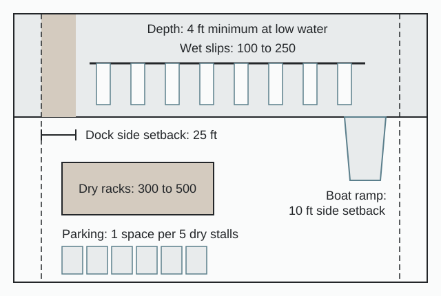
Determination: the program as proposed and as resized
As proposed, the model counts its program the way a developer does: 100 to 250 wet slips in the water and 300 to 500 racks in a building. As the code reads, it is one number. LDC 26-41 makes every rack a slip, and LDC 26-71(a)(4) tests every non-single-family slip against the Manatee Protection Plan [4]. Read that way, a building of 400 racks with 150 wet slips is a 550 slip facility for the manatee test [4]. The size of the dry stack is therefore a manatee question before it is a building question.
The county's slip determination sets the ceiling. Lee County Natural Resources runs the slip determination and GIS evaluation [13], against shoreline the applicant owns or controls, and shoreline created by dredge and fill after Oct. 24, 1989 does not count [4]. Slip credits move between sites under AC-13-21, and its rounding rule works against the buyer: the on-site maximum rounds up, the transferable number rounds down [7].
| Element | As proposed | As resized after code and site |
|---|---|---|
| Slip count | 100 to 250 wet slips plus 300 to 500 racks | One total, racks included, capped by the county slip determination; the resized number depends on the parcel's siting category and is not stated for the model [4, 13] |
| Shoreline basis | The parcel's frontage | Owned or controlled shoreline only; dredge and fill shoreline created after Oct. 24, 1989 excluded [4] |
| Dry stack | Program height and rack count | Height fixed in the CPD [28]; outdoor storage screened 8 ft toward residential and 6 ft toward a street [24]; slab, ship store and fuel equipment raised for BFE + 1 ft [25] |
| Dock field | Slip layout to the riparian lines | 25 ft side setbacks; 10 ft for a boat ramp; 4 ft at mean low water plus 1 ft clearance; least-impact placement over seagrass [4] |
| Shoreline edge | Bulkheaded edge | No new or expanded seawalls on natural waterbodies; riprap at a 12-inch minimum average [4] |
| Parking | Spaces for racks, slips and the store | 1 space per 5 dry storage stalls; 10 per boat ramp; wet slip ratio not stated; up to 10% administrative reduction [23] |
| Fuel | Fuel dock | Aboveground tanks over 550 gallons under 62-762 [29]; NFPA 303 review by the fire district [3] |
A rebuild in the county's beach town shows how a rack count moves once boat size and forklift geometry are fixed. The Fort Myers Beach Observer reported that the Town of Fort Myers Beach Council approved the Loggerhead Fish-Tale Marina plans on Aug. 18, 2025: dry storage reconfigured for larger boats, from 441 to 434 boats in 68,000 sq ft, with a wider center lane for forklifts, a deviation allowing a zero setback for the restaurant rehab, and temporary fueling stations during the dock buildout [34, 35].
Height is the other number settled in the hearing. No by-right dry stack height is stated here: the height sections of the code are LDC 34-2174 and 34-2175 (Ord. 23-22), and the dry stack height is set in the CPD [28]. Scaled architectural elevations above mean high water are a required hearing exhibit for dock departures, 34-202(b)(5)d.4 [4], and commercial architectural elevations, signed and sealed, are required for the Development Order (DO Guide item 28; LDC 10-604) [3]. 3D renderings of the stack are built on the same massing.
Site data table and yield
The site data table on the sheet carries these lines. Values marked "not stated" are set by the county determination or by the engineer of record, not by a published number.
| Site data item | Model value or rule |
|---|---|
| Wet slips | 100 to 250 (program); each counts as a slip [4] |
| Dry racks | 300 to 500 (program); "open or covered racks" count as slips [4] |
| Slip total for the manatee test | Wet slips plus racks, per LDC 26-45(b)(7) and 26-79; 400 racks with 150 wet slips is 550 slips [4] |
| Shoreline basis | Owned or controlled, measured per LDC 26-41 [4] |
| Lee siting ratio | Not stated; county determination [13] |
| Dock side setbacks | 25 ft; boat ramp 10 ft [4] |
| Depth at mean low water | 4 ft minimum plus 1 ft keel clearance [4] |
| Dry stack height | Set in the CPD [28] |
| Parking | 1 per 5 dry storage stalls; 10 per boat ramp; wet slip ratio not stated; up to 10% administrative reduction [23] |
| Outdoor storage screening | 8 ft toward residential; 6 ft toward a street [24] |
| Flood | BFE + 1 ft freeboard [25] |
| Protected species | Survey required for all PD rezonings and for large developments (over 10 acres or over 2 acres impervious) [3] |
| Mangroves | 3:1 replacement, 80% survival over 5 years [4] |
| Fuel storage | Aboveground tanks over 550 gallons under 62-762 [29] |
| Hurricane | Emergency Preparedness Plan for marinas and multi-slip docks, 10-154(21) [3] |
Yield. The model's yield is the slip determination, and it is not stated until the county runs it. The published records give the benchmarks a developer can hold a parcel against:
- Jug Creek Marina MPD: 1.11 acres; Green Flash marina and restaurant CPD: 1.05 acres [10].
- Loggerhead Fish-Tale Marina, as reported: 434 boats in 68,000 sq ft of dry storage [35].
- Legacy Harbour Marina, per the operator's press release: 131 slips of 40 to 150 ft [36].
- Port Phoenix: WINK News reported in 2022 that the marina "can store up to 239 boats up to 50 feet in length" [37], and the Cape Coral Breeze reported that the original 2021 county proposal was "dry storage for 200 boats" [38].
Comparable approvals and denials, 2021 to 2026
Each row names its source type. A county hearing outcome appears only where a primary record or a named report states it.
| Project | Jurisdiction | Program | Status | Source type |
|---|---|---|---|---|
| Loggerhead Fish-Tale Marina rebuild | Town of Fort Myers Beach | Post-Ian rebuild; dry storage 434 boats (from 441); 68,000 sq ft dry storage [35] | Approved by the Town Council, Aug. 18, 2025, as reported [34] | Local news (secondary) |
| Legacy Harbour Marina rebuild | City of Fort Myers | 131 slips, 40 to 150 ft; operated under lease with the City [36] | Construction began early 2025, per the operator's press release [36] | Operator press release |
| Moss Marina / The Arches | Town of Fort Myers Beach | About 5 acres, three resort structures, 263 hotel rooms, upgraded marina, as reported [39] | First hearing approved, as reported; final adoption not stated [39] | Lifestyle publication (secondary) |
| Jug Creek Marina MPD (DCI2026-00010) | Unincorporated Lee | 1.11 acres, IM to MPD [10] | Under review (received Mar. 6, 2026) [10] | County DCI report |
| Green Flash Restaurant CPD (DCI2022-00058) | Unincorporated Lee | 1.05 acres, C-1 and CM to CPD; restaurant and marina [10] | Under review since Nov. 21, 2022 [10] | County DCI report |
| Safe Harbor Port Phoenix Marina (Lee County's Waterway Estates Marina) | Unincorporated Lee | Lessee capital: "approximately $9,000,000 in Capital Improvements are planned and funded by the lessee" (SH Marinas, LLC) [40]; federal files SERO-2024-01619 and SAJ-2005-08448 [41] | County zoning outcome not stated here | Lee County marina page; NOAA record |
At Loggerhead, as reported, the rack count fell from 441 to 434 as the racks were reconfigured for larger boats, and the restaurant rehab needed a zero setback deviation [34]. At Port Phoenix the county marina page carries the lessee's capital commitment and the NOAA record carries the federal file numbers [40, 41]. The two unincorporated filings in review, Jug Creek and Green Flash, both use planned development districts [10].
Cost and phasing benchmarks
The published figures are state lease terms, state and county fees, and one operator's capital commitment.
| Item | Figure | Source date |
|---|---|---|
| Submerged lands lease base rate | $0.156623 per sq ft per year, a five-year CPI average updated each March 1 [15] | Page modified Feb. 20, 2026 |
| Lease rent | Greater of 6% of annual income, the base fee or the minimum annual fee [42] | Rule 18-21.011(1)(a)1. |
| Minimum annual fee | $423.89 effective March 1, 2007, adjusted annually [43] | Rule 18-21.011(1)(b)4. |
| First-year surcharge, new leases | 25% [42, 44] | 18-21.011(1)(b)3.; Dec. 17, 2024 Board of Trustees agenda |
| Annual rent increase cap | 10% [42] | Rule 18-21.011 |
| Lease discounts | 10% Clean Marina [45]; 30% if 90% or more open to the public first come, first served [15] | 2026 |
| Lease term | 5 years standard; 10 years if 90% public; up to 25 years under 18-21.008(2)(a) [15] | 2026 |
| Sovereign material severance | $1.25 per cubic yard, 18-21.011(3)(a)3. [44] | Dec. 17, 2024 |
| FDEP individual ERP, marina this size | $14,000 [14] | Rule 62-4.050(4)(h) |
| FDEP ERP, 10 to 29 slips | $1,500 [14] | Same page |
| FDEP general permit determination | $250 [14] | Same page |
| County Development Order | $3,000 + $60 per acre [5] | Fee manual, May 2026 |
| Building plan review | $0.10 per sq ft ($525 min for a new building); structural inspections $0.15 per sq ft ($500 min) [5] | Effective Apr. 15, 2026 (Reso 26-03-20) |
| Port Phoenix lessee capital | "approximately $9,000,000 in Capital Improvements are planned and funded by the lessee" [40] | Lee County Waterway Estates page |
| Dry stack rent, 30 ft boat, Miami (market evidence, secondary) | $950 to $1,350 per month (2026) [46] | Boat repair blog |
Phasing. Lee CPD rules deem the unbuilt balance of a planned development vacated if a phase "was not commenced within one year of its programmed date" [47]. A phased marina therefore commits to a phase schedule it can meet, and county approval before the state lease sets the earliest start for any work over sovereign submerged lands [4]. At Loggerhead, temporary fueling stations operate during the dock buildout, as reported [34]. On Port Phoenix, the North Fort Myers Neighbor reported a 30-year lease term with two 10-year extension options [48].
Submittal anatomy: preliminary plan and engineer of record
The pre-application meeting accepts a conceptual plan; the Development Order requires every plan signed and sealed [3]. The table splits each submittal item between what the preliminary site plan carries and what the engineer or architect of record adds.
| Stage and item | Preliminary site plan | Engineer or architect of record |
|---|---|---|
| Pre-application: conceptual plan [3] | Yes | No |
| CPD: master concept plan with uses, access, buffers, open space [2] | Yes | Refines at the DO |
| CPD, dock departures: dimensioned plan view, scaled elevations above MHW, benthic survey, 34-202(b)(5)d.4 [4] | Plan view, elevations, slip table | Benthic survey (consultant) |
| Slip location and quantity; riparian lines; channel width, LDC 26-45(b)(6) [4] | Yes | Surveyed riparian lines (PSM) |
| Manatee watercraft-slip determination, LDC 26-45(b)(7) [4] | Slip tabulation with racks counted | County determination |
| DO: cover letter, fee, notarized affidavit, 10-153 [3] | No | No |
| DO: legal description and sealed sketch, 10-154(1); title, 10-154(2); boundary survey, 10-154(3) [3] | No | PSM |
| DO: existing conditions, 10-154(6); location map, 10-154(6)(a) [3] | Location map | PSM or PE |
| DO: site plan with buildings, travel ways, parking, cross sections and Lee Plan consistency, 10-154(7) and (27) [3] | Layout, parking, yield tables | Sealed final by PE |
| DO: traffic impact statement, 10-154(10) [3] | Trip inputs | Traffic engineer |
| DO: FLUCCS map; protected species survey and plan, 10-154(6)(f), (14), (15) [3] | No | Environmental consultant |
| DO: utility plan, 10-154(7)(j); drainage plan, 10-154(7)(k) [3] | Footprints only | PE |
| DO: landscape plan, 10-154(7)(l) and 10-416 [3] | Concept planting and buffers | RLA |
| DO: exterior lighting and photometric plan, 10-154(8) and 34-625 [3] | Fixture locations | PE or lighting designer |
| DO: Tall Structures Permit, 10-154(13) [3] | Height data | Applicant or PE |
| DO: fire protection plan, 10-154(20) [3] | Fire lanes | Fire protection engineer |
| DO: Emergency Preparedness Plan for marinas and multi-slip docks, 10-154(21); hurricane mitigation, 2-482 [3] | No | Operator or consultant |
| DO: commercial architectural elevations, 10-604 and 10-620 [3] | 3D views and elevations | Architect (sealed) |
| DO: SWP3 at 1 acre or more of disturbance, 14-477 [3] | No | PE |
| DO: community meeting notes (North Fort Myers and others; Ch. 33) [3] | Presentation graphics | Applicant |
| DO: state and federal permit applications, 10-154(22) [3] | No | PE and consultants |
| Construction drawings, LDC 26-45(c) [4] | No | PE or registered architect, sealed |
| As-built survey, LDC 26-45(d)(3) [4] | No | PSM, sealed |
The sealing rule for dock work is written into Chapter 26:
"Work relating to industrial, commercial or multi-family projects may require a development order in accordance with Chapter 10 and construction drawings sealed by a professional engineer (P.E.) or registered architect." [4]
The preliminary plan is what the engineer of record builds the sealed Development Order set on. For how the two stages divide nationally, see preliminary versus final site plans.
Conditions and handoff
The conditions a Lee County marina plan inherits come from the code and the county's flood and environmental rules.
- Floodplain. Substantially damaged or improved buildings must comply, "including elevating not just to BFE but also to Freeboard" [25]. Lee defines substantial improvement as work "the cost of which equals or exceeds 50% of the market value of the structure" [16]. The flood ordinances include 15-09, 22-30, 25-09 and 26-01 [16], and Ord. 22-30 repealed local definition amendments [27].
- Manatee zones. The county slip cap sits alongside the FWC state manatee zones (68C-22.005) and the federal areas under 50 CFR 17.108(c) [49].
- Hurricane readiness. The Development Order requires an Emergency Preparedness Plan for marinas and multi-slip docks under 10-154(21), with hurricane mitigation under 2-482 [3].
- Stormwater and surveys. A SWP3 applies at 1 acre or more of disturbance (LDC 14-477), and sites over 10 acres or with more than 2 acres of impervious area need a FLUCCS map and a protected species survey (LDC 10-154(14), 10-473) [3].
- Tall buildings. A Tall Structures Permit from the Lee County Port Authority sits in the Development Order submittal, 10-154(13) [3].
- Clean Marina. The designation is voluntary, requires 100% of regulatory requirements and at least 60% of best management practices, and has a "Clean and Resilient" tier [50, 51]; a designated Clean Marina earns the 10% lease discount under s. 253.0346(3)(a)1. and Rule 18-21.011(1)(b)15a. [15].
At handoff, the engineer of record takes the slip tabulation, the riparian geometry, the dry stack footprint and height, the buffers and the parking count from the preliminary plan and builds the sealed set: surveyed riparian lines and as-built survey by a PSM, construction drawings by a PE or registered architect, and the stormwater, utility and tank design [3, 4]. For the wider permitting stack, see marina development in America and USACE, coastal zone and municipal overlay requirements. Developers weighing a dry stack against an upland storage yard can compare RV and boat storage site plans and the RV and boat storage model in Montgomery County, Texas. Other Florida model projects are the express car wash in Hillsborough County and the RV park in Polk County; the full set is in case studies.
Frequently asked questions
Do dry racks count against the manatee slip limit in Lee County?
Yes. Lee County LDC 26-41 defines a slip to include "open or covered racks", so every rack in a dry stack building counts toward the Manatee Protection Plan slip determination, alongside the wet slips [4].
Can I get the state submerged lands lease before county approval?
No. LDC 26-45(b)(7) requires county approval first wherever a submerged lands lease is required from the Florida Department of Environmental Protection [4].
How much parking does a dry stack need in Lee County?
Table 34-2020(b) of the Land Development Code sets 1 space per 5 dry storage stalls and 10 spaces per boat ramp. The wet slip ratio sits in Note (1) of the same table and is not stated here [23].
What does the state charge for a marina?
How long does a planned development rezoning take in Lee County?
The county states that the average time to complete a planned development rezoning is 9 months, depending on completeness of the application when submitted [2].
Is a hurricane plan required for a Lee County marina?
Yes. The Development Order submittal requires an Emergency Preparedness Plan for marinas and multi-slip docks under LDC 10-154(21) [3].
Which fire standard governs a marina in Florida?
What triggers flood upgrades on a marina rebuild?
Work costing 50% or more of the market value of the structure is a substantial improvement, and the building must then be elevated to the base flood elevation plus 1 ft of freeboard [25].
Sources
- 1)Hearing Examiner, Lee County. Accessed 2026-10-09.
- 2)Planned Development, Lee County Department of Community Development. Accessed 2026-10-09.
- 3)Development Order: Application and Approval Guide (updated 8/3/2021), Lee County Department of Community Development. Accessed 2026-10-09.
- 4)Lee County Ordinance No. 22-24, amending the Land Development Code (Chapter 26 docks, seawalls and marinas; Chapter 34), Lee County Board of County Commissioners. Accessed 2026-10-09.
- 5)External Fees and Charges Manual (AC 3-10, May 2026), Lee County Board of County Commissioners. Accessed 2026-10-09.
- 6)Ordinance No. 09-23, amending the Lee County Land Development Code (Manatee Protection Plan), Lee County. Accessed 2026-10-09.
- 7)Administrative Code AC-13-21 (slip credit transfer), Lee County Board of County Commissioners. Accessed 2026-10-09.
- 8)The Lee County Land Development Code, Ordinance No. 94-24, Lee County. Accessed 2026-10-09.
- 9)Ordinance No. 12-01, amending the Lee County Land Development Code, Lee County. Accessed 2026-10-09.
- 10)DCI Cases Under Review (report of Oct. 4, 2026), Lee County Department of Community Development. Accessed 2026-10-09.
- 11)The Lee Plan, as amended through December 2025, Lee County. Accessed 2026-10-09.
- 12)Lee Plan Map 12, Water-Dependent Overlay Zones, Lee County. Accessed 2026-10-09.
- 13)Manatee Protection Plan, Lee County Natural Resources. Accessed 2026-10-09.
- 14)BIPP Fees (JCP and ERP), Florida Department of Environmental Protection. Accessed 2026-10-10.
- 15)FAQ: Use of State-Owned Land, Florida Department of Environmental Protection. Accessed 2026-10-09.
- 16)Floodplain Management (Flood Protection Information), Lee County Department of Community Development. Accessed 2026-10-09.
- 17)Building Permit Fee Schedule, Lee County Department of Community Development. Accessed 2026-10-10.
- 18)SB 180, 2025 Bill Summaries, The Florida Senate. Accessed 2026-10-09.
- 19)Reports on the SB 180 lawsuits, Sept. 30 and Oct. 8, 2025 (secondary), Central Florida Public Media. Accessed 2026-10-09.
- 20)Chapter 166 Section 033, 2025 Florida Statutes, The Florida Senate. Accessed 2026-10-10.
- 21)Bill Analysis and Fiscal Impact Statement, SB 1080 (2025), The Florida Senate. Accessed 2026-10-10.
- 22)High-Velocity Hurricane Zones, Florida Building Code, Building, Sec. 1620, Florida Building Commission. Accessed 2026-10-09.
- 23)Lee County Land Development Code Sec. 34-2020, Required parking spaces (code mirror), Lee County (via elaws). Accessed 2026-10-09.
- 24)Lee County Land Development Code Sec. 34-3005, Storage facilities (code mirror), Lee County (via elaws). Accessed 2026-10-10.
- 25)Substantial Improvement/Substantial Damage, Lee County Department of Community Development. Accessed 2026-10-09.
- 26)Lee County Ordinance No. 15-09 (flood), Lee County. Accessed 2026-10-10.
- 27)Lee County Ordinance No. 22-30 (flood), Lee County. Accessed 2026-10-09.
- 28)Lee County Ordinance No. 23-22 (height, Secs. 34-2174 and 34-2175), Lee County. Accessed 2026-10-10.
- 29)Fla. Admin. Code R. 62-762.301, Applicability (Florida Department of Environmental Protection rule, via Cornell LII), Cornell Legal Information Institute. Accessed 2026-10-09.
- 30)Florida Fire Prevention Code (FFPC), Florida Department of Financial Services, Division of State Fire Marshal. Accessed 2026-10-10.
- 31)Fla. Admin. Code R. 69A-60.005, Publications referenced in the Florida Fire Prevention Code (State Fire Marshal rule, via elaws), elaws. Accessed 2026-10-10.
- 32)Fla. Admin. Code R. 69A-3.012, NFPA and other standards adopted (State Fire Marshal rule, via Cornell LII), Cornell Legal Information Institute. Accessed 2026-10-10.
- 33)Fla. Admin. Code R. 62-762.501, Shop fabricated storage tanks (Florida Department of Environmental Protection rule, via Cornell LII), Cornell Legal Information Institute. Accessed 2026-10-09.
- 34)Loggerhead Fish-Tale Marina gets approvals for rehabilitation work (Fort Myers Beach Observer, Aug. 19, 2025; secondary), Fort Myers Beach Observer. Accessed 2026-10-10.
- 35)Fort Myers Marina Approved for Repairs, Upgrades (secondary), Toy Storage Nation. Accessed 2026-10-10.
- 36)Legacy Harbour Marina Redevelopment After Hurricane Ian (operator press release), Legacy Harbour Marina. Accessed 2026-10-10.
- 37)WINK News, Nov. 1, 2022 (Port Phoenix dry storage capacity; secondary), WINK News. Accessed 2026-10-09.
- 38)Cape Coral Breeze, Nov. 8, 2021 (Port Phoenix dry storage proposal; secondary), Cape Coral Breeze. Accessed 2026-10-09.
- 39)The New Face of Fort Myers Beach (lifestyle publication; secondary), SWFL Life. Accessed 2026-10-10.
- 40)Waterway Estates Marina, Lee County. Accessed 2026-10-09.
- 41)SERO-2024-01619, Safe Harbor Port Phoenix Marina, NOAA Fisheries, Southeast Regional Office (NOAA Institutional Repository). Accessed 2026-10-09.
- 42)Fla. Admin. Code R. 18-21.011, Payments and Fees (Board of Trustees of the Internal Improvement Trust Fund rule, via Cornell LII), Cornell Legal Information Institute. Accessed 2026-10-09.
- 43)Fla. Admin. Code R. 18-21.011, Payments and Fees (Board of Trustees of the Internal Improvement Trust Fund rule, via elaws), elaws. Accessed 2026-10-10.
- 44)Agenda, Board of Trustees of the Internal Improvement Trust Fund, Dec. 17, 2024, Florida Department of Environmental Protection. Accessed 2026-10-09.
- 45)Clean Marina: Steps to Designation, Florida Department of Environmental Protection. Accessed 2026-10-09.
- 46)Slip vs Dry Stack vs Trailer: Miami Boat Storage Costs (secondary), Boat Repair Miami. Accessed 2026-10-10.
- 47)Lee County Ordinance No. 01-03, Lee County. Accessed 2026-10-09.
- 48)North Fort Myers Neighbor, July 19, 2022 (Port Phoenix lease term; secondary), North Fort Myers Neighbor. Accessed 2026-10-09.
- 49)Manatee Data and Maps, Florida Fish and Wildlife Conservation Commission. Accessed 2026-10-09.
- 50)Clean Marina Program, Florida Department of Environmental Protection. Accessed 2026-10-09.
- 51)Florida Clean Marina Guide to Designation, Florida Department of Environmental Protection. Accessed 2026-10-10.